Approximate Location Map
Large Map »
Latitude: 51.3933 / 51°23'35"N
Longitude: 0.3916 / 0°23'29"E
OS Eastings: 566487
OS Northings: 168740
OS Grid: TQ664687
Mapcode National: GBR NN5.PT8
Mapcode Global: VHJLR.Q7XR
Plus Code: 9F3299VR+8M
Entry Name: Owletts' Well House
Listing Date: 26 July 1983
Grade: II
Source: Historic England
Source ID: 1350224
English Heritage Legacy ID: 356760
ID on this website: 101350224
Location: Cobham, Gravesham, Kent, DA12
County: Kent
District: Gravesham
Civil Parish: Cobham
Built-Up Area: Cobham
Traditional County: Kent
Lieutenancy Area (Ceremonial County): Kent
Church of England Parish: Cobham St Mary Magdalene
Church of England Diocese: Rochester
Tagged with: House
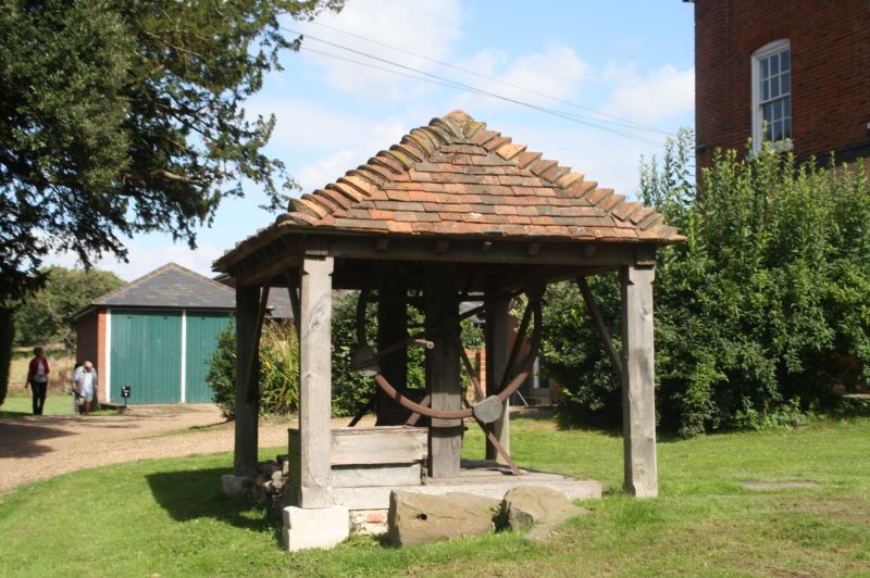
TQ 66 NE COBHAM THE STREET
5/31 (north side)
Owletts' Well House
II
Cl9. Timber-framed with hipped tiled roof and cast iron wheel.
Listing NGR: TQ6651068734
External links are from the relevant listing authority and, where applicable, Wikidata. Wikidata IDs may be related buildings as well as this specific building. If you want to add or update a link, you will need to do so by editing the Wikidata entry.


Other nearby listed buildings
