Approximate Location Map
Large Map »
Latitude: 51.4972 / 51°29'49"N
Longitude: -0.166 / 0°9'57"W
OS Eastings: 527403
OS Northings: 179175
OS Grid: TQ274791
Mapcode National: GBR 6K.XG
Mapcode Global: VHGQZ.2MLM
Plus Code: 9C3XFRWM+VH
Entry Name: 24, Ovington Gardens SW3
Listing Date: 7 November 1984
Grade: II
Source: Historic England
Source ID: 1357157
English Heritage Legacy ID: 422381
ID on this website: 101357157
Location: Brompton, Kensington and Chelsea, London, SW3
County: London
District: Kensington and Chelsea
Electoral Ward/Division: Brompton & Hans Town
Parish: Non Civil Parish
Built-Up Area: Kensington and Chelsea
Traditional County: Middlesex
Lieutenancy Area (Ceremonial County): Greater London
Church of England Parish: Holy Trinity with St Paul, Onslow Sq and St Augustine, Sth Kensington
Church of England Diocese: London
Tagged with: Building
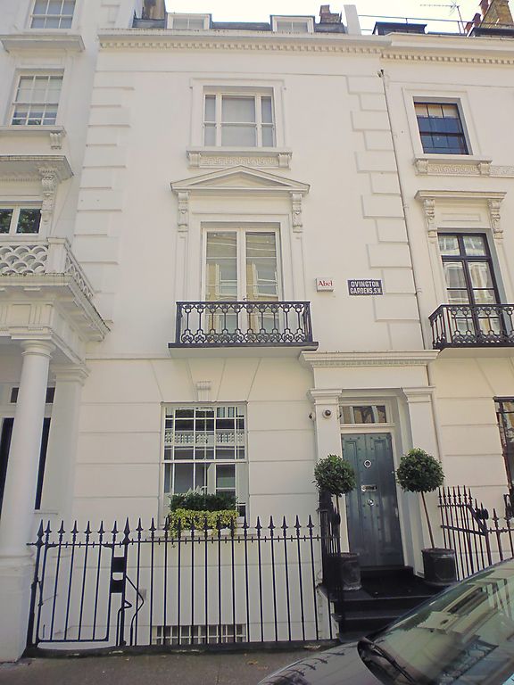
TQ 2779 SW OVINGTON GARDENS SW3
40/33
No 24
GV
II
Mid C19. Terraced house. Stucco. Four storeys. Two windows wide. First floor
balcony. Listed mainly for group value with Ovington Square.
Listing NGR: TQ2740379175
External links are from the relevant listing authority and, where applicable, Wikidata. Wikidata IDs may be related buildings as well as this specific building. If you want to add or update a link, you will need to do so by editing the Wikidata entry.


Other nearby listed buildings
