Approximate Location Map
Large Map »
Latitude: 54.1033 / 54°6'11"N
Longitude: -2.7917 / 2°47'30"W
OS Eastings: 348327
OS Northings: 467775
OS Grid: SD483677
Mapcode National: GBR 8NYZ.DV
Mapcode Global: WH841.24W6
Plus Code: 9C6V4635+88
Entry Name: Meeting Hall (Former Free Grammar School)
Listing Date: 7 November 1983
Grade: II
Source: Historic England
Source ID: 1362401
English Heritage Legacy ID: 181795
ID on this website: 101362401
Location: Bolton-le-Sands, Lancaster, Lancashire, LA5
County: Lancashire
District: Lancaster
Civil Parish: Bolton-le-Sands
Built-Up Area: Bolton-le-Sands
Traditional County: Lancashire
Lieutenancy Area (Ceremonial County): Lancashire
Church of England Parish: Bolton-le-Sands Holy Trinity
Church of England Diocese: Blackburn
Tagged with: Architectural structure
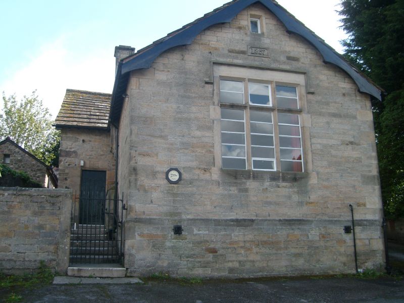
SD 48 67 BOLTON-LE-SANDS ST. MICHAEL'S LANE
13/29 Meeting Hall
(Former Free Grammar School)
II
School. 1637 and 1857. 1637 range to rear is of slobbered cobbles and
limestone with sandstone dressings and stone slate roof. 1857 wing running
north towards road is of squared punched sandstone on its gable and east
walls. One storey. South wall of school has a large window framed by
sections of C17th rebated and chamfered surround. East gable wall has
C19th mullioned and transomed window. West gable has: chimney with
weathered offset, moulded string and cornice; a blocked one-light
chamfered window surround; a blocked 2-light rebated and chamfered window
under the eaves. Only the east end of the front wall of the original
school remains, with a plain chamfered surround with date '1637' in raised
letters in a sunken panel in the lintel. C19th wing has a mullioned and
transomed window with hood mould in its gable, with date '1857' on panel
above and a one-light window under the apex. Bellcote with bell on top
of the gable. East wall has chimney corbelled out.
Listing NGR: SD4832767775
External links are from the relevant listing authority and, where applicable, Wikidata. Wikidata IDs may be related buildings as well as this specific building. If you want to add or update a link, you will need to do so by editing the Wikidata entry.


Other nearby listed buildings
