Approximate Location Map
Large Map »
Latitude: 51.2108 / 51°12'38"N
Longitude: 0.7547 / 0°45'16"E
OS Eastings: 592502
OS Northings: 149337
OS Grid: TQ925493
Mapcode National: GBR RVY.5LS
Mapcode Global: VHKK6.1T9P
Plus Code: 9F326Q63+8V
Entry Name: Church Hill Cottage
Listing Date: 10 October 1980
Grade: II
Source: Historic England
Source ID: 1362993
English Heritage Legacy ID: 180708
ID on this website: 101362993
Location: Charing Heath, Ashford, Kent, TN27
County: Kent
District: Ashford
Civil Parish: Charing
Built-Up Area: Charing Heath
Traditional County: Kent
Lieutenancy Area (Ceremonial County): Kent
Tagged with: Cottage
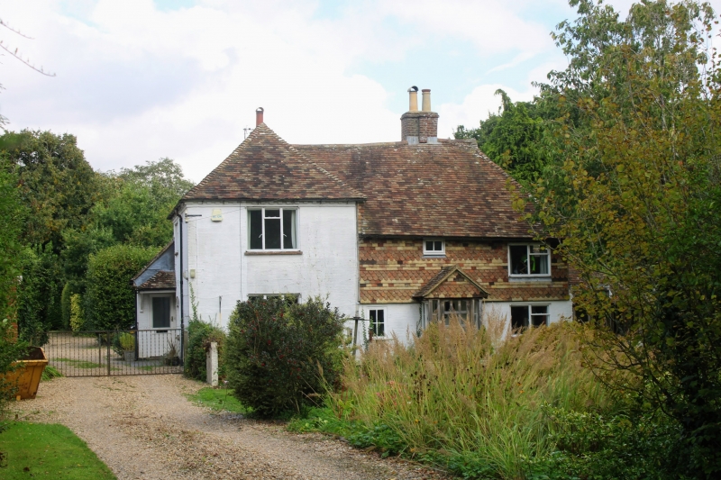
1.
5272 CHARING CHURCH HILL
Charing Heath
Church Hill Cottage
TQ 94 NW 10/117
II
2.
C16 or earlier timber-framed building refronted. Two storeys stuccoed. Hipped
tiled roof with brick stack. Timber-framing exposed on the right-hand side
with diagonal braces. Left side hipped roofed wing of higher elevation.
The right-hand part is tile-hung on the first floor. Three casement windows.
Simple doorcase.
Listing NGR: TQ9250249337
External links are from the relevant listing authority and, where applicable, Wikidata. Wikidata IDs may be related buildings as well as this specific building. If you want to add or update a link, you will need to do so by editing the Wikidata entry.


Other nearby listed buildings
