Approximate Location Map
Large Map »
Latitude: 51.1118 / 51°6'42"N
Longitude: -2.4525 / 2°27'8"W
OS Eastings: 368422
OS Northings: 134816
OS Grid: ST684348
Mapcode National: GBR MX.BBGJ
Mapcode Global: VH8BG.FBV2
Plus Code: 9C3V4G6X+P2
Entry Name: The Gate Piers and Gates, About 22 Metres North North West of the Church, and All of the Boundary Walls and Other Gateways, Church of Saint Mary
Listing Date: 29 August 1984
Grade: II
Source: Historic England
Source ID: 1366338
English Heritage Legacy ID: 261676
ID on this website: 101366338
Location: Bruton, Somerset, BA10
County: Somerset
District: South Somerset
Civil Parish: Bruton
Built-Up Area: Bruton
Traditional County: Somerset
Lieutenancy Area (Ceremonial County): Somerset
Tagged with: Architectural structure
ST6834NW
8/188
BRUTON CP
STATION ROAD (West side)
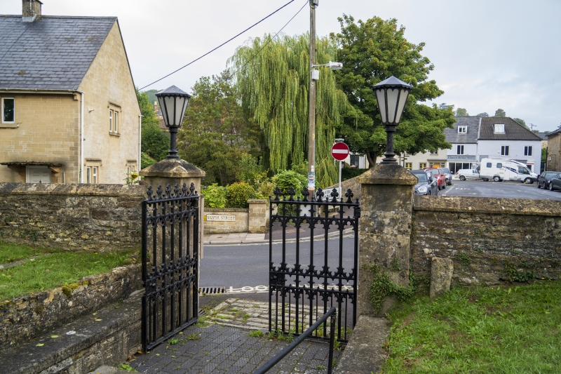
The gate piers and gates, about 22 metres North North West of the Church, and all of the boundary walls and other gateways, Church of Saint Mary
GV II
Boundary walls with gate piers and gates. Mostly C18 and C19. Local and Doulting stone, with cast iron gates. North
boundary wall averages 2.5 metres high, with coursed rubble capped with pitched coping stones; near gates a plaque
recording flood levels; central gate piers of square ashlar with pyramidal caps on which are set C20 wrought iron
lights; fine pair cast iron gates in Gothic style; similar gate piers in North West corner, with ashlar sweep wall to
Vicarage (qv), C20 wooden gates. West wall averages 2 metres high, with stepped pitched coping; rubble, with some old
tombstones set in. South wall has vertical stone copings to rubble, again with tombstones set in; opposite East wall
of chancel is a 4-centred arched gateway, possibly the private gateway for the Berkeley family, owners of the former
Abbey; to left of gateway is fragment of chest tomb of Thomas Hill, died 1637. East wall also rubble, rather lower in
average height. The North and East walls are important elements in the street scene; the South and West walls define
the limits between churchyard and Bruton Abbey, finally demolished in 1786. (Couzens P, Bruton in Selwood, Abbey
Press, Sherborne 1972).
Listing NGR: ST6842234816
External links are from the relevant listing authority and, where applicable, Wikidata. Wikidata IDs may be related buildings as well as this specific building. If you want to add or update a link, you will need to do so by editing the Wikidata entry.


Other nearby listed buildings
