Approximate Location Map
Large Map »
Latitude: 53.2911 / 53°17'28"N
Longitude: -1.2879 / 1°17'16"W
OS Eastings: 447562
OS Northings: 377365
OS Grid: SK475773
Mapcode National: GBR MZFC.YY
Mapcode Global: WHDF5.5JYT
Plus Code: 9C5W7PR6+CR
Entry Name: Barlborough Infants School
Listing Date: 23 March 1989
Grade: II
Source: Historic England
Source ID: 1372098
English Heritage Legacy ID: 79208
ID on this website: 101372098
Location: Barlborough, Bolsover, Derbyshire, S43
County: Derbyshire
District: Bolsover
Civil Parish: Barlborough
Built-Up Area: Barlborough
Traditional County: Derbyshire
Lieutenancy Area (Ceremonial County): Derbyshire
Church of England Parish: Barlborough St James
Church of England Diocese: Derby
Tagged with: School building
SK 47 NE
1/38
PARISH OF BARLBOROUGH
OFF HIGH STREET
(North Side)
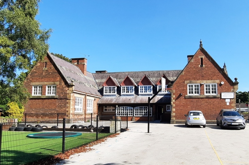
Barlborough Infants School
II
Village school. 1870. Red brick with sandstone dressings. Flush angle quoins. Steeply
pitched Welsh slate roof with alternating bands of fishscale slates. Stone coped
gables with moulded kneelers, ball finials and spearhead finials. Prominent and
symmetrically arranged brick and ashlar ridge stacks. Dentil eaves cornice. H-plan.
Single storey. South elevation of 2-3-2 bays, the three centre bays gabled and
projecting. Stepped arrangement of three large windows under plain stone lintels.
Timber mullions and transoms and secondary glazing bars. Single slit window in the
gable. Flanked by two large three light windows under plain stone lintels. Timber
mullions and a transom. The west and east elevations have similar 2-light windows
high up in the gables and similar 3-light windows to the return elevations. On the
west side the inner elevation of the H has a lean-to veranda with broad segmental
arched windows within. Four large 3-light gabled roof dormers above. Similar
elevation to east, but with a small C20 addition to the ground floor.
Listing NGR: SK4756277365
External links are from the relevant listing authority and, where applicable, Wikidata. Wikidata IDs may be related buildings as well as this specific building. If you want to add or update a link, you will need to do so by editing the Wikidata entry.


Other nearby listed buildings
