Approximate Location Map
Large Map »
Latitude: 51.0196 / 51°1'10"N
Longitude: -3.1076 / 3°6'27"W
OS Eastings: 322407
OS Northings: 125051
OS Grid: ST224250
Mapcode National: GBR M1.J0JS
Mapcode Global: FRA 46CF.55C
Plus Code: 9C3R2V9R+RX
Entry Name: 29-47, Staplegrove Road
Listing Date: 5 August 1988
Grade: II
Source: Historic England
Source ID: 1372429
English Heritage Legacy ID: 361619
ID on this website: 101372429
Location: North Town, Somerset, TA1
County: Somerset
District: Somerset West and Taunton
Electoral Ward/Division: Taunton Fairwater
Parish: Non Civil Parish
Built-Up Area: Taunton
Traditional County: Somerset
Lieutenancy Area (Ceremonial County): Somerset
Tagged with: Building
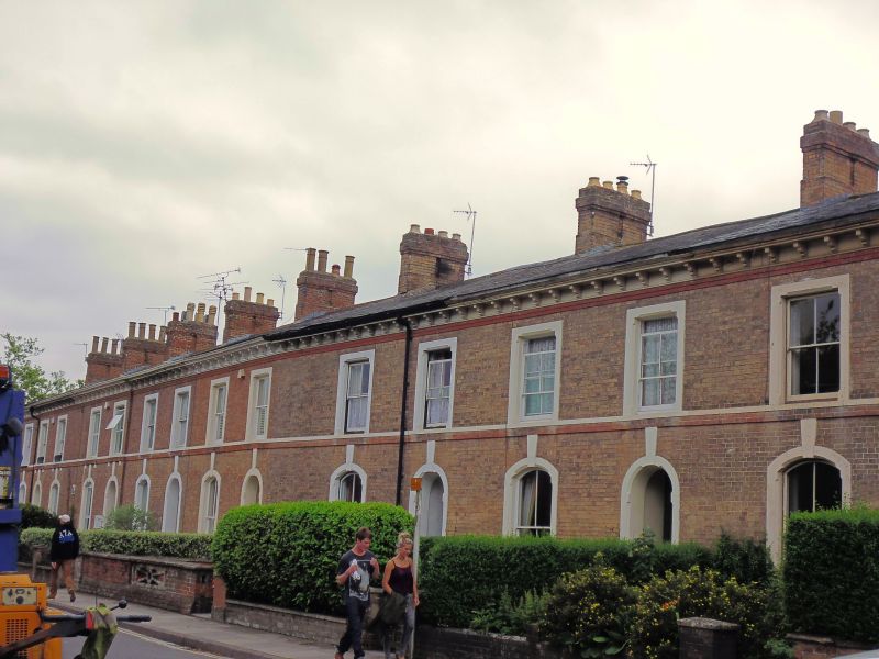
STAPLEGROVE ROAD
ST 2225 + 2325
(south side)
6/371 Nos 29-47 (odd)
GV II
Terrace of ten houses. Mid-late C19, of two builds. Pinkish brick in Flemish bond,
with red brick bands; Welsh slate roofs. 2 storeys, each of 2 bays. The original
terrace comprised nos 29-39, Nos 33 and 35 breaking forward, and the whole
symmetrical; a straight-joint between Nos 39 and 41 indicates the addition of Nos
41-47. Openings have painted surrounds with chamfers, the doorways round-headed,
the ground floor windows segmental-headed and the first floor windows square-headed.
The ground floor openings have tall keystones which rise into stepped red brick
plat band. Similar eaves band with moulded gutter brackets. The doors are recessed,
of 8 vertical panels (upper panels now glazed), with 2-pane overlights; windows
have 4-pane sashes, Nos 33 and 35 are emphasised by having cill blocks to first
floor windows below the plat band, which breaks forward under the windows. Broad
cross-ridge stacks. Ashlar coping to gable ends.
Listing NGR: ST2243725040
External links are from the relevant listing authority and, where applicable, Wikidata. Wikidata IDs may be related buildings as well as this specific building. If you want to add or update a link, you will need to do so by editing the Wikidata entry.


Other nearby listed buildings
