Approximate Location Map
Large Map »
Latitude: 53.2575 / 53°15'27"N
Longitude: -1.3976 / 1°23'51"W
OS Eastings: 440284
OS Northings: 373558
OS Grid: SK402735
Mapcode National: GBR LZPR.6Z
Mapcode Global: WHDF9.HDP2
Plus Code: 9C5W7J52+2X
Entry Name: Large Centre Block to Brimington County Junior Mixed School
Listing Date: 26 September 1977
Grade: II
Source: Historic England
Source ID: 1372649
English Heritage Legacy ID: 83337
ID on this website: 101372649
Location: Brimington, Chesterfield, Derbyshire, S43
County: Derbyshire
District: Chesterfield
Civil Parish: Brimington
Built-Up Area: Chesterfield
Traditional County: Derbyshire
Lieutenancy Area (Ceremonial County): Derbyshire
Church of England Parish: Brimington St Michael and All Angels
Church of England Diocese: Derby
Tagged with: Architectural structure
DEVONSHIRE STREET
1.
5169 (North-East Side)
Brimington
Large centre block to
Brimington County
Junior Mixed School
SK 4073 10/196
II
2.
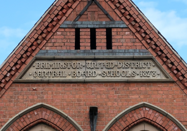
1878. Stone lettered band on facade reads "Brimington Tapton District Central
Board Schools. Red brick with blue brick bands and stone dressings. Brick eaves
cornice. Slates with cresting. Irregular facade. Gable with Gothic arch containing
flat arched windows below, short tower with heavy corbelled cornice and blocking
course, 2 lancet windows. Hipped gable with 3 light stone bay window then advanced
gable with 2 Gothic arched windows with plate tracery and dripstone moulds. Single
storey Gothic arched entrance with half hipped gabled dormer above and small 3
light window at each side. End advanced gabled section. Gothic arch containing
flat arched later casements and doors. School enlarged 1888.
Listing NGR: SK4028473558
External links are from the relevant listing authority and, where applicable, Wikidata. Wikidata IDs may be related buildings as well as this specific building. If you want to add or update a link, you will need to do so by editing the Wikidata entry.


Other nearby listed buildings
