Approximate Location Map
Large Map »
Latitude: 51.2104 / 51°12'37"N
Longitude: -2.6465 / 2°38'47"W
OS Eastings: 354938
OS Northings: 145889
OS Grid: ST549458
Mapcode National: GBR MN.439X
Mapcode Global: VH89S.2TSZ
Plus Code: 9C3V6963+5C
Entry Name: Number 6 and Associated Boundary Walling
Listing Date: 12 November 1953
Grade: II
Source: Historic England
Source ID: 1382897
English Heritage Legacy ID: 483283
ID on this website: 101382897
Location: Wells, Somerset, BA5
County: Somerset
District: Mendip
Civil Parish: Wells
Built-Up Area: Wells
Traditional County: Somerset
Lieutenancy Area (Ceremonial County): Somerset
Tagged with: Building
WELLS
ST5445 CATHEDRAL GREEN
662-1/7/29 (North side)
12/11/53 No.6
and associated boundary walling
GV II
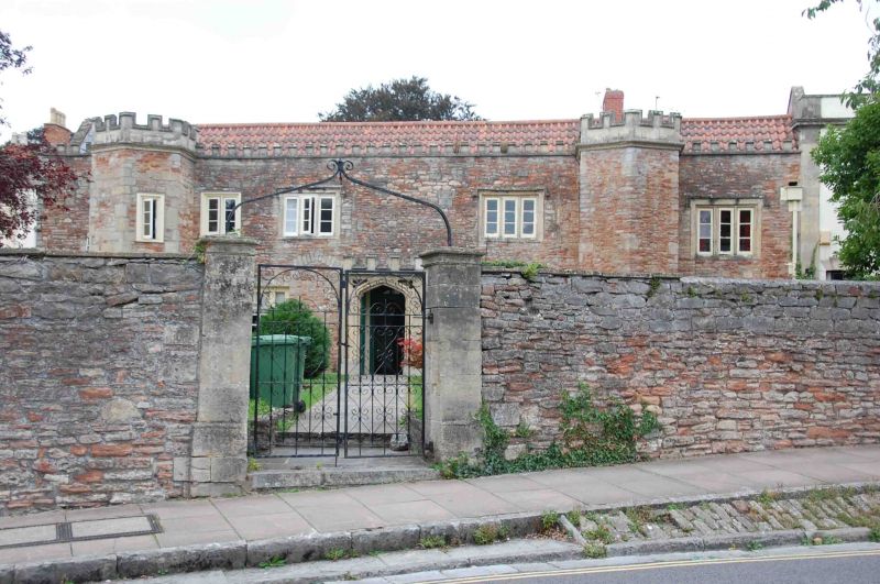
House. Medieval origins, remodelled c1800 in Picturesque
Gothic style. Local stone rubble, ashlar dressings, clay
pantiled roof between coped gables, brick stacks.
EXTERIOR: 2 storeys, 5 bays. Battlemented parapet to main
block. Bay 1 has a hexagonal plan projection with cornice
moulding and possibly earlier battlemented parapet, with two
single-light 3-pane windows, similar projection without
windows between bays 4 and 5. Bays 2, 4 and 5 have composite
east windows of 4+12+4 panes, with the tops of the middle unit
radially glazed, the lintels over having false keystones. Bay
3 has a projecting stone porch in a Gothic style, with
4-centred moulded arch, pierced spandrels and crenellated
parapet. To first floor are a 2-light casement to left of bay
2, and to right of bay 2 and to bays 4 and 5 are plain stone
3-light mullioned windows in slight recesses with square
labels all with wood casements having three panes; pointed
relieving arch to right of lower bay 2.
Triple gable west elevation to Saddler Street, with late C19
windows in segmental-arched recesses, with central glazed door
in deep recess. C20 extension to the rear northwards (Kendrick
Court).
INTERIOR: not inspected.
SUBSIDIARY FEATURES: extending from the north-west corner of
the house is a length of rubble walling about 4m high, with
battlemented top, (probably of C19 date), for about 17m
length, a similar wall extends southwards from the south-west
corner of the house along Sadler Street for about 22m, curving
round to meet part of Brown's Gate (qv) where it becomes lower
with a flat coping, blocked arched doorway at south end of
high section: return along Cathedral Green about 2.5m high,
with square ashlar gate piers in centre, having a wrought-iron
overthrow for a former lamp, the whole length of the wall
being an important element of the street scene in both Saddler
Street and Cathedral Green.
Listing NGR: ST5494245894
External links are from the relevant listing authority and, where applicable, Wikidata. Wikidata IDs may be related buildings as well as this specific building. If you want to add or update a link, you will need to do so by editing the Wikidata entry.


Other nearby listed buildings
