Approximate Location Map
Large Map »
Latitude: 51.2104 / 51°12'37"N
Longitude: -2.6471 / 2°38'49"W
OS Eastings: 354891
OS Northings: 145892
OS Grid: ST548458
Mapcode National: GBR MN.434F
Mapcode Global: VH89S.2TFY
Plus Code: 9C3V6963+54
Entry Name: Saltyre House
Listing Date: 12 November 1953
Grade: II
Source: Historic England
Source ID: 1382915
English Heritage Legacy ID: 483318
ID on this website: 101382915
Location: Wells, Somerset, BA5
County: Somerset
District: Mendip
Civil Parish: Wells
Built-Up Area: Wells
Traditional County: Somerset
Lieutenancy Area (Ceremonial County): Somerset
Tagged with: House
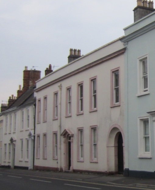
WELLS
ST5445 CHAMBERLAIN STREET
662-1/7/45 (North side)
12/11/53 No.4
Saltyre House
GV II
House in row. C15, refronted late C18. Rendered and
colourwashed, Welsh slate roof with coped gable to west and
abutment to east, concrete block chimney stacks. L-plan: C18
front block with parallel rear ranges, C15 to rear right and
c1800 to rear left.
EXTERIOR: 2 storeys with attics, 7 bays. Plinth, cornice,
plain parapet. Plain sash windows in moulded architraves,
entrance in bay 3, with a 6-panel door set in a semicircular
arched recess with fanlight, framed with pilasters carrying an
open pediment hood. Bay 7 has a wider semicircular arched
throughway with a pair of C20 doors. 3 flat-roofed dormers
behind parapet.
Behind building are two extensions running northwards, the
western being late C18/early C19, with Venetian windows, the
eastern wing apparently C15.
INTERIOR: C15 wing noted as having thick walls, with 3 upper
cruck frames visible in roof space, traces of a cambered
collar and some chamfered curved windbraces. Good late C18
dogleg staircase (not seen).
(Hale B: Vernacular Architecture Group Report: 1989-).
Listing NGR: ST5488945894
External links are from the relevant listing authority and, where applicable, Wikidata. Wikidata IDs may be related buildings as well as this specific building. If you want to add or update a link, you will need to do so by editing the Wikidata entry.


Other nearby listed buildings
