Approximate Location Map
Large Map »
Latitude: 51.2117 / 51°12'42"N
Longitude: -2.6467 / 2°38'48"W
OS Eastings: 354922
OS Northings: 146035
OS Grid: ST549460
Mapcode National: GBR MN.3WTD
Mapcode Global: VH89S.2SNY
Plus Code: 9C3V6963+M8
Entry Name: Northam House with Boundary Wall
Listing Date: 12 November 1953
Grade: II
Source: Historic England
Source ID: 1383046
English Heritage Legacy ID: 483464
ID on this website: 101383046
Location: St Andrew, Somerset, BA5
County: Somerset
District: Mendip
Civil Parish: Wells
Built-Up Area: Wells
Traditional County: Somerset
Lieutenancy Area (Ceremonial County): Somerset
Tagged with: Building
WELLS
ST5446 NEW STREET
662-1/6/182 (West side)
12/11/53 No.15
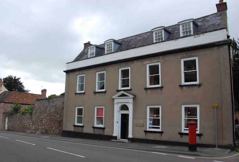
Northam House, with boundary wall
GV II
Detached house on corner site, partly occupied by dental
surgery. Possibly late C17, C18 refronting, modified. Rendered
over rubble with false ashlar lining, stone dressings painted,
Welsh slate roof between coped gables, brick end chimney
stacks.
PLAN: a symmetrical front range has two long wings enclosing a
very narrow courtyard, later mostly filled; these wings have
steep roofs, and that to the left (S) has a large ridge stack
near its outer end.
EXTERIOR: 2 storeys with attics, 5 bays. Plinth, end
pilasters, cornice, plain parapet. Plain sash window with
exposed boxes in simple openings to centre bay a C20 door, up
one step, set in a semicircular arched opening with leaded
coloured glass fanlight, framed with Doric pilasters carrying
triglyph frieze and pediment. 2 roof dormers with segmental
roofs, having 12-pane sash windows.
INTERIOR: not inspected.
SUBSIDIARY FEATURES: extending from SE corner southwards, a
local random rubble stone wall, starting at first-floor sill
level, with sweep down to about 2.5m high, with plain coping,
boarded gate in south end, the wall being an important element
in the street scene at this point. The site was developed by
C15-a house burnt down between 1402 and 1409, and not rebuilt
until c1515.
(Town and Country Planning Working Papers: Scrase AJ: Wells: A
Study of Town Origins: Bristol: 1982-: 67).
Listing NGR: ST5492246035
External links are from the relevant listing authority and, where applicable, Wikidata. Wikidata IDs may be related buildings as well as this specific building. If you want to add or update a link, you will need to do so by editing the Wikidata entry.


Other nearby listed buildings
