Approximate Location Map
Large Map »
Latitude: 51.2115 / 51°12'41"N
Longitude: -2.6438 / 2°38'37"W
OS Eastings: 355125
OS Northings: 146010
OS Grid: ST551460
Mapcode National: GBR MN.3XPL
Mapcode Global: VH89S.4T53
Plus Code: 9C3V6964+JF
Entry Name: Boundary Walls to Numbers 14-27
Listing Date: 12 November 1953
Last Amended: 31 May 2000
Grade: I
Source: Historic England
Source ID: 1383200
English Heritage Legacy ID: 483618
ID on this website: 101383200
Location: St Andrew, Somerset, BA5
County: Somerset
District: Mendip
Civil Parish: Wells
Built-Up Area: Wells
Traditional County: Somerset
Lieutenancy Area (Ceremonial County): Somerset
Tagged with: Wall
WELLS
ST5445 VICARS' CLOSE
662-1/7/335 (West side)
12/11/53 Boundary walls to Nos 14-27
(Consecutive)
(Formerly Listed as:
VICAR'S CLOSE
Nos.1-13 AND 14-27 (Consecutive))
GV I
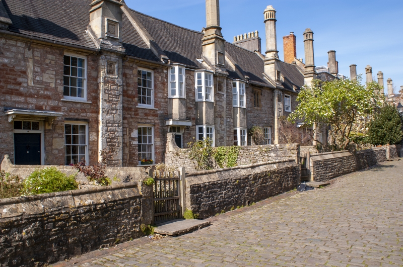
Walls enclosing gardens of row of houses. Mid C15, with some
C19 modifications, restored 1976-83. Local roughly squared
stone rubble with Doulting ashlar dressings. Front boundary
walls on average 4m from front of houses, with returns along
side boundaries, and with openings opposite doorways to
houses, average 1m high, with roll-top and pitched face
copings.
At the north end is a return link eastward to the Vicars
Chapel (qv). Variations are; No.15 has ashlar piers with
moulded pyramidal caps to gateway, No.16 has low ashlar walls
surmounted by wrought-iron railings having simple collared
points and urn finials to cast bracketed standards, with pair
of gates to match and piers at each end, No.17 has plain stone
coping, No.22 has a higher boundary wall and what may be an
original gateway with 4-centred gate arch having mock
crenellated top, and a timber boarded gate, and No.27 has a
sweep up to a similar stone gateway abutting part of the
Vicars Hall (qv).
These walls break up the original quadrangular form of Vicars'
Close, having been erected in response to demands from the
Vicars for gardens. They enclose the approx 140m long street,
which narrows and rises slightly towards the N end, and is
completely paved with setts. Probably each house had a raised
gateway when the walls were first constructed.
(Colchester L S: Wells Cathedral: a History: Shepton Mallet:
1982-: 212 - 225; Buildings of England: Pevsner N: North
Somerset and Bristol: London: 1958-: 319).
Listing NGR: ST5513245992
External links are from the relevant listing authority and, where applicable, Wikidata. Wikidata IDs may be related buildings as well as this specific building. If you want to add or update a link, you will need to do so by editing the Wikidata entry.


Other nearby listed buildings
