Approximate Location Map
Large Map »
Latitude: 55.6126 / 55°36'45"N
Longitude: -2.6724 / 2°40'20"W
OS Eastings: 357740
OS Northings: 635649
OS Grid: NT577356
Mapcode National: GBR 93SJ.7W
Mapcode Global: WH7WQ.X6L4
Plus Code: 9C7VJ87H+22
Entry Name: House To North Of Farmsteading, Drygrange House
Listing Name: Drygrange, No 4 Drygrange Stable Cottages (House to North of Steading)
Listing Date: 4 June 1991
Category: C
Source: Historic Scotland
Source ID: 353005
Historic Scotland Designation Reference: LB18839
Building Class: Cultural
ID on this website: 200353005
Location: Melrose
County: Scottish Borders
Electoral Ward: Leaderdale and Melrose
Parish: Melrose
Traditional County: Roxburghshire
Tagged with: House
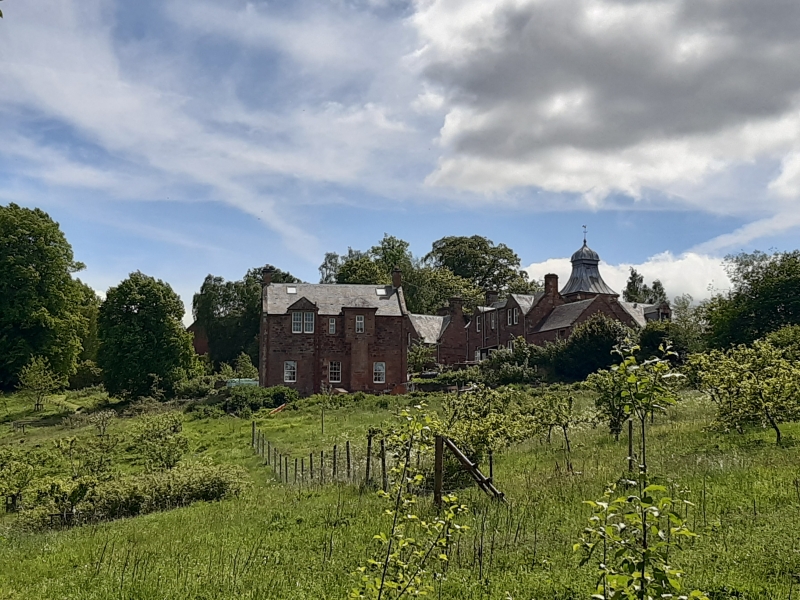
Circa 1890, G H Kinnear and J M Dick Peddie. Single-storey and basement, 3-bay, rectangular-plan house situated on ground sloping steeply to N. Red sandstone rubble with ashlar dressings. Pedimented dormer-headed windows breaking eaves. Timber panelled door in pilastered doorcase at 1st floor, reached by forestair to centre bay. In-and-out quoins.
Predominantly 12-pane glazing to timber sash and case windows. Slated roof; end stacks; stone skews.
Part of a B-Group including 'Drygrange House (Grangehall Care Home, Formerly St Andrew's College) Including Garden Terrace Walls to South'; 'Drygrange, Walled Garden'; ' Drygrange, North Lodge Including Gates, Gatepiers and Quadrant Walls'; 'Drygrange, South Lodge Including Gates, Gatepiers and Quadrant Walls'; 'Drygrange, House to North of Steading'; 'Drygrange, Stables and Steading' and 'Drygrange, Summerhouse'.
Located a short distance NE of the former Drygrange steading, this house was possibly built for the resident groom as part of the extension of the steading and stable range in 1889. It is a distinctive split-level house of red sandstone, notable for its principle entance at 1st floor with pedimented dormer breaking eaves making good use of its sloping site. Its contextual association with the steading adds to its interest, as an integral part of the wider grouping.
List description and statutory address updated at resurvey (2010).
External links are from the relevant listing authority and, where applicable, Wikidata. Wikidata IDs may be related buildings as well as this specific building. If you want to add or update a link, you will need to do so by editing the Wikidata entry.


Other nearby listed buildings
