Approximate Location Map
Large Map »
Latitude: 51.8133 / 51°48'47"N
Longitude: -2.7111 / 2°42'40"W
OS Eastings: 351071
OS Northings: 212975
OS Grid: SO510129
Mapcode National: GBR FL.WVH6
Mapcode Global: VH86T.YPLB
Plus Code: 9C3VR77Q+8G
Entry Name: NO.12 St.james Square, Gwent
Listing Date: 15 August 1974
Last Amended: 10 August 2005
Grade: II
Source: Cadw
Source ID: 2325
Building Class: Domestic
ID on this website: 300002325
Location: Prominently sited within the main group of historic buildings on the east side of Monmouth and about 300m east of the town square.
County: Monmouthshire
Town: Monmouth
Community: Monmouth (Trefynwy)
Community: Monmouth
Built-Up Area: Monmouth
Traditional County: Monmouthshire
Tagged with: Building
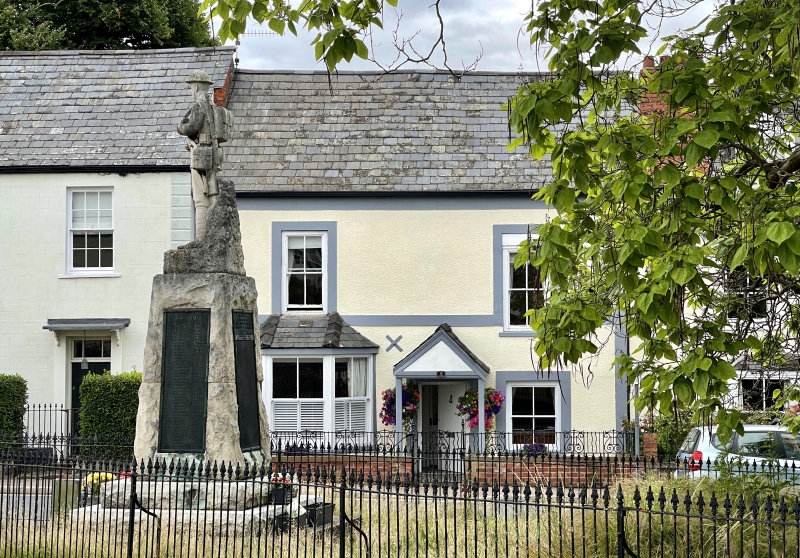
A possibly c1600 house with its external treatment dating from the C19.
Rendered and painted front with a Welsh slate roof. T-shaped plan with a street range and rear wing. Two storeys, two windows. Slightly off-centre gabled porch. Later C19 2 over 2 pane sashes; canted three window bay on left side at ground floor. Rendered and painted gabled rear wing.
The interior is very difficult of interpretation since its use as a school boarding and master's house has meant the disguising of many features; as well as having broken through walls, different floor levels and divided rooms. Some slight chamfered beams. The only significant ancient feature readily seen is the roof structure which shows evidence of fire and of several periods of construction and alteration. Principal rafter roofs, timber-framed partitions with lath-and-plaster.
Included for its special architectural interest as a multi-period building of definite character near Monmouth town centre.
External links are from the relevant listing authority and, where applicable, Wikidata. Wikidata IDs may be related buildings as well as this specific building. If you want to add or update a link, you will need to do so by editing the Wikidata entry.


Other nearby listed buildings
