Approximate Location Map
Large Map »
Latitude: 53.221 / 53°13'15"N
Longitude: -4.164 / 4°9'50"W
OS Eastings: 255619
OS Northings: 371510
OS Grid: SH556715
Mapcode National: GBR 5N.12Z2
Mapcode Global: WH547.09FK
Plus Code: 9C5Q6RCP+9C
Entry Name: Menai Suspension Bridge (CROWN PROPERTY)
Listing Date: 2 August 1988
Last Amended: 2 August 1988
Grade: I
Source: Cadw
Source ID: 4049
Building Class: Transport
Also known as: Cario'r ffagl Olymaidd dros Bont Menai, Mai 2012
ID on this website: 300004049
Location: Spanning the Menai Straits to W of the city.
County: Isle of Anglesey
Community: Menai Bridge (Porthaethwy)
Community: Menai Bridge
Built-Up Area: Menai Bridge
Traditional County: Anglesey
Tagged with: Suspension bridge Road bridge Toll bridge
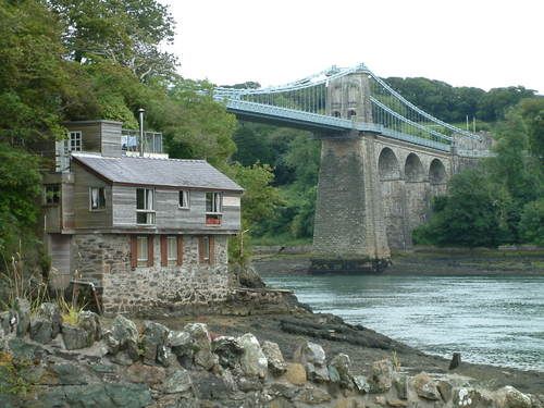
Built 1818 to 1826 by Thomas Telford. This renowned bridge completed the London to Holyhead Turnpike Road. The site was chosen because of its steep bankis enabling the erection of a high bridge to satisfy the Admiralty's requirements. The construction was a development of Telford's own design for an unexecuted bridge over the Mersey and that by Captain Brown over the Tweed. Opened 30 January 1826 - 100ft high, 28ft wide roadway and with a single suspended span of 579ft; 130ft longer than any previously built bridge. Reconstructed 1938-40 by Sir Alexander Gibb.
Coursed rubble Penmon masonry with ashlar facings to the tapered suspension towers or 'pyramids' from which the deck is hung on a system of 16 chains (originally iron, now steel) with pins. These are carried down at either end to a point deep in the rock. 4 arches to Anglesey side and 3 to Bangor side, over tapered piers; voussoirs, impost bands and bracket cornice above. The later metal pedestrian walkways are further bracketed out; originally there was just the narrow central pavement. Each carriageway passes under the towers through semi-circular arched openings, matched above by paired blind recesses over inscribed tablets. The handrails continue as far as the low tapered piers with pyramidal caps at each end and on the mainland side trellised railings continue to either side and sweep round to terminate in similar piers with panelled recesses.
At the mainland end the suspending members are taken into the former Toll House, a low 3-storey classical ashlar faced building with channelled rustication to ground floor. 3-bay front facing bridge with broad and taller end pilasters and arched entries; central bay advanced and taller and flanking bays have 12-pane sash windows below blind recessed panels; arched openings to ground floor 'loggia'. 2-bay side elevations with similar detail. The building ramps down at rear which is part modernised. Later toll houses were built at either end of the bridge.
External links are from the relevant listing authority and, where applicable, Wikidata. Wikidata IDs may be related buildings as well as this specific building. If you want to add or update a link, you will need to do so by editing the Wikidata entry.


Other nearby listed buildings
