History in Structure

Pont Llanbedr

A Grade II Listed Building in Llanbedr, Gwynedd

More Photos »
Approximate Location Map
Large Map »

Coordinates

Latitude: 52.8203 / 52°49'13"N

Longitude: -4.1006 / 4°6'2"W

OS Eastings: 258543

OS Northings: 326818

OS Grid: SH585268

Mapcode National: GBR 5R.V6D0

Mapcode Global: WH565.ZCHR

Plus Code: 9C4QRVCX+4Q

Entry Name: Pont Llanbedr

Listing Date: 30 November 1966

Last Amended: 29 October 2003

Grade: II

Source: Cadw

Source ID: 4783

Building Class: Transport

ID on this website: 300004783

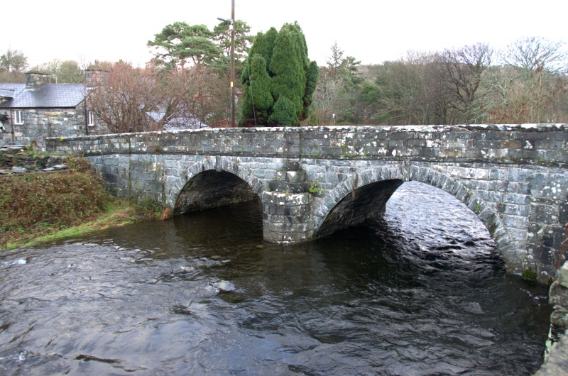
Location: Carries the A496 and spans the Afon Artro in the heart of the village of Llanbedr.

County: Gwynedd

Community: Llanbedr

Community: Llanbedr

Built-Up Area: Llanbedr

Traditional County: Merionethshire

Tagged with: Bridge Road bridge

Find accommodation in
Llanbedr

History

Mid C17 bridge with stone on parapet wall bearing the date 1642; largely reconstructed circa 1850.

Exterior

Bridge of 2 spans with segmental arches of voussoirs with pendant keystones. Built of coursed stone with dripcourse and raking stone slab parapet coping. Stepped semi-circular cutwater on both sides between the arches and flanking raking buttresses. On the W side of the E parapet is a carved panel with the date 1642 flanked by a hammer and trowel, the date on the upper part of the panel has been chipped off, but is said to have been 1850.

Reasons for Listing

Listed as an excellent and substantial mid C17 roadbridge.

Scheduled Ancient Monument: ME026

External Links

External links are from the relevant listing authority and, where applicable, Wikidata. Wikidata IDs may be related buildings as well as this specific building. If you want to add or update a link, you will need to do so by editing the Wikidata entry.

Recommended Books

Other nearby listed buildings

  • II Wenallt Stores
    Located at the SW side of the A496 in the heart of the village of Llanbedr, opposite the junction with the road to Pentre Gwynfryn and to NW of Pont Llanbedr.
  • II Moriah Calvinist Chapel
    Located on the E side of the A496 at the S end of the village. Set back slightly from the street in a raised railed yard.
  • II Milestone
    Set alongside the E side of the A496 at the S end of the village of Llanbedr.
  • II* Church of St Peter
    Within a subrectangular churchyard set well back from the NE side of the A496 at the N end of the village of Llanbedr.
  • II Old Dairy Farm, Plas-y Bryn Farm
    Llanbedr
  • II Agricultural range to rear of Gilfach Goch
    About 700m S of village. Above village reached via minor road and track. Built into hillside in sheltered position. To rear (N) of Gilfach Goch.
  • II Gilfach Goch
    About 700m S of village. Above village reached via minor road and track. Built into hillside in sheltered position.
  • II Pigsty and brewhouse range at Gilfach Goch
    About 700m S of village. Above village reached via minor road and track. Built into hillside in sheltered position. The pigsties are to W of the house.

BritishListedBuildings.co.uk is an independent online resource and is not associated with any government department. All government data published here is used under licence. Please do not contact BritishListedBuildings.co.uk for any queries related to any individual listed building, planning permission related to listed buildings or the listing process itself.

British Listed Buildings is a Good Stuff website.