Approximate Location Map
Large Map »
Latitude: 53.2975 / 53°17'51"N
Longitude: -4.6296 / 4°37'46"W
OS Eastings: 224851
OS Northings: 381065
OS Grid: SH248810
Mapcode National: GBR GMYZ.N3J
Mapcode Global: WH31B.VCMX
Plus Code: 9C5Q79XC+25
Entry Name: Kingsland Windmill
Listing Date: 1 August 1952
Last Amended: 25 July 1994
Grade: II*
Source: Cadw
Source ID: 5762
Building Class: Industrial
Also known as: Saint George's Windmill
St. George's Windmill
St George's Windmill
George's Windmill
ID on this website: 300005762
Location: Prominent building set within a modern housing estate reached W off B4545 approximately 1km south of Holyhead town centre.
County: Isle of Anglesey
Community: Holyhead (Caergybi)
Community: Holyhead
Built-Up Area: Holyhead
Traditional County: Anglesey
Tagged with: Windmill
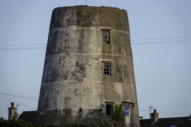
Built cal 1820-30; erected by the local builder Hugh Hughes. The cap and sails were removed during the 2nd World War for fear of being too conspicuous. Since then Kingsland Mill has been closed but retains its machinery. Also formerly known as Melin yr Ogof or St George’s Mill.
Conical tower windmill; stone built with recent whitewashed render.
4-storeys with square-headed openings and small-pane windows arranged in 4 regular tiers to W and E sides; between the windows on 1st floor are opposing doorways which, depending on which side the sails were, opened onto the staging (now lost but wooden joists remain). Boarded door ground floor entrance to N. Remains of perimeter wall built to keep away cattle.
The principal importance of this windmill is the survival of an exceptional amount of the original machinery, much of which is near to working order. Beginning at the Bin Floor at top where the original chain wheel that drove the cap may survive; 3 hoppers are retained together with the sack hoist that brought the grain to this level; iron crown wheel. Below is the Stone Floor where the hoppers feed into horses and onto stone vats - 2 out of the 3 stones (made from local stone) are complete with their associated machinery but in the case of the 3rd stone the machinery is partly broken. The 1st floor retains rare examples of in situ dressers where the flour was graded. Other surviving machinery includes gearing, stone governors and secondary drives.
Graded II* as an exceptionally important example of a C19 windmill because of the retention of an almost complete set of machinery original to this building.
External links are from the relevant listing authority and, where applicable, Wikidata. Wikidata IDs may be related buildings as well as this specific building. If you want to add or update a link, you will need to do so by editing the Wikidata entry.


Other nearby listed buildings
