Approximate Location Map
Large Map »
Latitude: 53.3017 / 53°18'6"N
Longitude: -4.5971 / 4°35'49"W
OS Eastings: 227035
OS Northings: 381451
OS Grid: SH270814
Mapcode National: GBR HM0Z.C0H
Mapcode Global: WH42H.C84P
Plus Code: 9C5Q8C23+M5
Entry Name: Bailiff's Tower and with boundary wall, gates and attached outbuildings at Penrhos Home Farm
Listing Date: 22 February 1993
Last Amended: 30 June 1998
Grade: II
Source: Cadw
Source ID: 5766
Building Class: Agriculture and Subsistence
ID on this website: 300005766
Location: Located at the heart of the Penrhos Coastal Park at the SE end of Holy Island; reached by private driveway N of the A5(T) and c1.25km NNE of the N end of the Stanley Embankment. The Bailiff's Tower li
County: Isle of Anglesey
Community: Holyhead (Caergybi)
Community: Holyhead
Locality: Penrhos Coastal Park
Traditional County: Anglesey
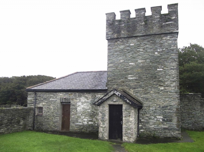
The Penrhos estate was the principal seat on Holy Island and became the home of the Stanley family in 1763. Penrhos house was completely remodelled for John Thomas Stanley in early C19; the Bailiff's Tower (part of the home farm) is probably contemporary with this remodelling, built c1802-8. The house became ruinous after 1945 and was later almost entirely demolished. The estate was bought by Anglesey Aluminium in 1969 and made into a country park in 1972. The estate buildings were being refurbished when inspected, May 1997.
Two-storey rubble tower with distinctive crenellated parapet concealing slate roof. Voussoirs to square-headed openings, now with modern small-pane window windows. Outside flight of steps to S. Hipped roofed range to rear with 2 broad camber-headed openings, renewed in earlier openings. The home farm boundary wall abuts the left(N) side of the modernised range to rear of the tower, linking it to a long, single storey, rubble range with grouted slate roof and modern small-pane windows in square-headed openings. The boundary wall then advances from the left(N) side of the gable end of this range and returns to run in a northerly direction; c2m N of the return is a gateway with square gate piers with pyramidal stone caps, N of the gateway the wall is taller, rendered, and crenellated.
Listed as a striking example of a C19 estate building in the castellated style characteristic of the Penrhos estate buildings of this period; part of a group with the barn and cartsheds at Penrhos Home Farm.
External links are from the relevant listing authority and, where applicable, Wikidata. Wikidata IDs may be related buildings as well as this specific building. If you want to add or update a link, you will need to do so by editing the Wikidata entry.


Other nearby listed buildings
