Approximate Location Map
Large Map »
Latitude: 51.8563 / 51°51'22"N
Longitude: -4.3083 / 4°18'29"W
OS Eastings: 241129
OS Northings: 220037
OS Grid: SN411200
Mapcode National: GBR DG.T807
Mapcode Global: VH3LH.8LQV
Plus Code: 9C3QVM4R+GM
Entry Name: 1
Listing Date: 19 May 1981
Last Amended: 28 November 2003
Grade: II
Source: Cadw
Source ID: 9424
Building Class: Domestic
ID on this website: 300009424
Location: Situated close to the junction with Dark Gate.
County: Carmarthenshire
Community: Carmarthen (Caerfyrddin)
Community: Carmarthen
Built-Up Area: Carmarthen
Traditional County: Carmarthenshire
Tagged with: Building
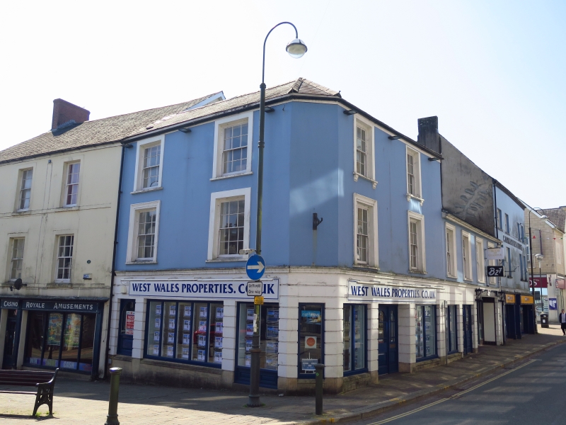
Early to mid-C19 former Half Moon hotel, which later included the former Nags Head in Nos 8-9 Dark Gate adjoining. The hotel was established in 1806, and the Nags Head became the bar and spirit stores. Marked on Wood's map of 1834. Run by William Bright, then Mrs Bright to 1884, then her son-in-law Henry Cadle. In 1884 Mrs. C. M. Cadle listed as landlady, and in 1914 Mrs. Margaret Ann Askin. Used as YMCA during 1914-18 war. In 1926 premises of Lloyd & Thomas, estate agents. A restaurant in 1981. Since 1981 converted to flats with rear access and removal of interior features, also new shop front.
Former hotel, now flats over commercial premises. Three storeys with slate close-eaved roof and modern brick stack to left. Painted stucco 3-bay front with 12-pane horned sash windows on upper floors, in openings with thin stuccoed surrounds, narrow bands at sill levels. On ground floor, modern window in timber casing, in old opening, to left; modern shop front to centre and right, with centre door and shop-window of 4 long panes all in timber casing with pilasters and fascia.
Rear altered in late C20 has flat-roofed ground floor addition and metal stairs to upper floor flats, 2 doors each floor.
In 1981 a contemporary staircase with the balusters covered over and with slender turned newels was noted, removed during conversion to flats.
Included as a substantial late Georgian building, retaining some characteristic external detail, prominently set on a main crossroads.
External links are from the relevant listing authority and, where applicable, Wikidata. Wikidata IDs may be related buildings as well as this specific building. If you want to add or update a link, you will need to do so by editing the Wikidata entry.


Other nearby listed buildings
