Approximate Location Map
Large Map »
Latitude: 51.4845 / 51°29'4"N
Longitude: -3.6813 / 3°40'52"W
OS Eastings: 283351
OS Northings: 177512
OS Grid: SS833775
Mapcode National: GBR H8.KLQN
Mapcode Global: VH5HH.4YPC
Plus Code: 9C3RF8M9+QF
Entry Name: Tudor Cottage
Listing Date: 28 September 1989
Last Amended: 17 February 1998
Grade: II
Source: Cadw
Source ID: 11361
Building Class: Domestic
ID on this website: 300011361
Location: At the W end of old village, close to The Globe Inn and almost opposite number 22, the thatched house, also listed. Set back behind narrow rubble walled forecourt.
County: Bridgend
Town: Porthcawl
Community: Porthcawl
Community: Porthcawl
Locality: Newton
Built-Up Area: Porthcawl
Traditional County: Glamorgan
Tagged with: Cottage
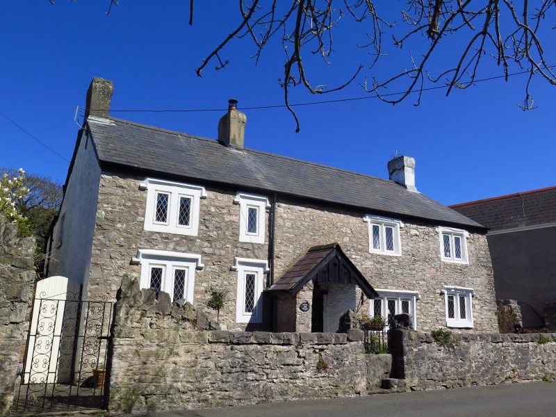
Early C17 sub medieval regional house enlarged to left possibly in early C19. Originally a two unit gable entry plan but doorway moved to present position, roof raised and outshut refurbished during enlargement. Replaced roof. Bordering old road linking the two medieval settlements of Newton and Nottage. Referred to as the Priest's House in deeds of 1610.
Built of rubble with painted freestone dressings; Welsh slate roof with rendered end stacks plus one over the original gable end above present entrance. Two storeys, 4 window range of square headed windows. To right, original house, 3 windows have two lights and one on ground floor has 3, all with sunk chamfered mullions, hoodmould and stops; replaced diamond quarry glazing. To left, the C19 extension, has on each floor one single and one double light window with unmoulded surrounds and mullions and higher hoodmoulds. Centre left stone porch has timber gable and decoratively panelled door. Rubble wall to front retains stone stile across entrance with small step to one corner and modern iron gate over. Rear extension.
No access to interior but previous list description records original separate hall and parlour, right of the later entrance, now combined. Ceiling has broad chamfered beams; hall fireplace has plain timber chamfered bressummer supported on dressed stone chamfered and stopped jambs; brick domed bake-oven to right; further small fireplace to former parlour to right. Stone stair right of main fireplace and built within projecting curved bay, has Tudor-arched chamfered doorway across angle, cross slab roof. Retains four-centred arched doorways, dressed stone fireplaces and stop chamfered beams. Original gable end entrance left was adjacent to main hall fireplace with winding stone stairs over bake oven on other side of stack.
Included as a sub medieval house with a substantial part of its original structure and fenestration intact and with a sympathetic C19 extension; group value with 22 Newton Nottage Road, the thatched house, almost opposite.
External links are from the relevant listing authority and, where applicable, Wikidata. Wikidata IDs may be related buildings as well as this specific building. If you want to add or update a link, you will need to do so by editing the Wikidata entry.


Other nearby listed buildings
