Approximate Location Map
Large Map »
Latitude: 53.3202 / 53°19'12"N
Longitude: -4.649 / 4°38'56"W
OS Eastings: 223653
OS Northings: 383637
OS Grid: SH236836
Mapcode National: GBR GMWX.R7M
Mapcode Global: WH314.KTD0
Plus Code: 9C5Q89C2+3C
Entry Name: Screen Wall to Soldier's Point House
Listing Date: 25 July 1994
Last Amended: 25 July 1994
Grade: II
Source: Cadw
Source ID: 14761
Building Class: Domestic
ID on this website: 300014761
Location: To N and NW of Soldier’s Point House.
County: Isle of Anglesey
Community: Holyhead (Caergybi)
Community: Holyhead
Locality: Soldier's Point
Built-Up Area: Holyhead
Traditional County: Anglesey
Tagged with: Wall
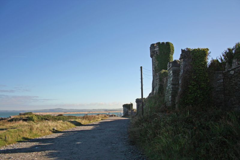
Elaborate castellated screen wall, circa 1849, house built for own use by Mr Rigby, contractor of Holyhead breakwater.
Dark local rubble with quartz banding and dressings to arrow loops; rustic, garden architecture type battlements.
To N of house, on rocky outcrop, high octagonal tower, castellated, with white quartz band, machicolations, faces of octagon with cruciform loops outlined in white quartz, doorways with shallow arches. Wall steps down to E to low square tower with shallow arched doorway and continues to turret and then similar square tower. To E of this, wall turns slightly SE stepping down between round turrets, terminating in low square tower with shallow-arched doorways. To W of high octagonal tower, wall steps down to blocked gateway flanked by towers, continuing to pier where wall runs S to run down E side of lane in simpler style but with rustic crenellations between stone piers; gateway to rear yard of Soldier’s Point House.
Included as impressive example of style, and for group value with Soldier’s Point House.
Group value.
External links are from the relevant listing authority and, where applicable, Wikidata. Wikidata IDs may be related buildings as well as this specific building. If you want to add or update a link, you will need to do so by editing the Wikidata entry.


Other nearby listed buildings
