Approximate Location Map
Large Map »
Latitude: 52.4865 / 52°29'11"N
Longitude: -3.437 / 3°26'13"W
OS Eastings: 302521
OS Northings: 288585
OS Grid: SO025885
Mapcode National: GBR 9M.JGGM
Mapcode Global: VH687.CRWR
Plus Code: 9C4RFHP7+H6
Entry Name: Llandinam Bridge
Listing Date: 15 February 1994
Last Amended: 26 November 1996
Grade: II*
Source: Cadw
Source ID: 15653
Building Class: Transport
ID on this website: 300015653
Location: Set at right angles to the main A.470 on the northern edge of Llandinam village, and carrying the by-road west over the River Severn.
County: Powys
Community: Llandinam
Community: Llandinam
Built-Up Area: Llandinam
Traditional County: Montgomeryshire
Tagged with: Bridge
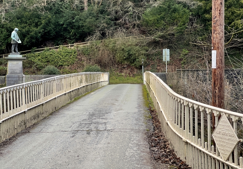
Constructed in 1846 to the design of Thomas Penson, the county surveyor of Montgomeryshire and cast by the Hawarden Ironworks to replace an earlier bridge. This is one of the first iron bridges in the County and is constructed on the Telford principle. This type of construction is similar to that used by Telford at Craigellachie and at Tewkesbury, on the bridges cast by William Hazeldine of Shrewsbury at the Plas Kinaston foundry. After Hazeldine's death in c.1840 some of the castings and patterns were sold to the Hawarden Iron Works. Given the fact that Telford was County Surveyor for Shropshire, his pioneering work on bridges would have been well known to Penson and as the Llandinam Bridge was actually cast at Hawarden, Telford's original castings may well have been re-used. It is also the first of a fine series of iron bridges spanning the River Severn. This bridge is of further historical interest in that the construction of the foundations and approaches was the first public contract for the famous industrialist, David Davies, who was born in Llandinam.
Cast-iron construction comprising a single segmental arch spanning 27m. The construction has three ribs, each comprising an arch ring, above which are raking struts carrying the single carriageway deck. The arch rings are each composed of segments of five cusped panels; the struts above forming a lattice work pattern and are tied and spaced apart by circular rods and cross members. At deck level there is a panel-fronted horizontal girder attached to which are cast iron railings with mid rail; and cusping to alternate panels at the top. The almost flat running surface, falling slightly to the W, is approximately 3.4m wide. At the E end, on the downstream side, the girder bears the cast inscription 'Thomas Penson County Surveyor', and on the upstream side, 'Hawarden Iron Works'. At the W end of both sides is the date '1846'. At the W end the railings continue and curve outwards towards the former railway station, and on the upstream side retain an iron diamond-shaped Montgomeryshire County Council loading restriction sign, dated 1906, restricting the superimposed axle weight to 3 tons. At the E end there are undressed stones parapets at the corners and attached railings that continue behind the statue of David Davies. The bridge is buttressed by raking abutments of large ashlar blcoks, sweeping out to terminal piers.
Graded II* as a well-preserved cast-iron bridge of special interest for its early construction on the Telford principle, and of group value with the pedestal and statue of David Davies of Llandinam.
External links are from the relevant listing authority and, where applicable, Wikidata. Wikidata IDs may be related buildings as well as this specific building. If you want to add or update a link, you will need to do so by editing the Wikidata entry.


Other nearby listed buildings
