History in Structure

Lower House Farmhouse

A Grade II Listed Building in Bronllys, Powys

More Photos »
Approximate Location Map
Large Map »

Coordinates

Latitude: 52.0315 / 52°1'53"N

Longitude: -3.2624 / 3°15'44"W

OS Eastings: 313490

OS Northings: 237758

OS Grid: SO134377

Mapcode National: GBR YV.G3F2

Mapcode Global: VH6BN.D6NJ

Plus Code: 9C4R2PJQ+H2

Entry Name: Lower House Farmhouse

Listing Date: 15 December 1995

Last Amended: 15 December 1995

Grade: II

Source: Cadw

Source ID: 16694

Building Class: Domestic

ID on this website: 300016694

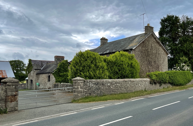
Location: A farmhouse set at right angles to the road, backing on to the farmyard to the NW.

County: Powys

Community: Bronllys

Community: Bronllys

Locality: Llyswen

Traditional County: Brecknockshire

Tagged with: Farmhouse

Find accommodation in
Bronllys

Exterior

Exterior: Mid C19, rubble stone with pecked ashlar dressings. Slate roof. Two storeys, the main house of 3 symmetrical bays with gable stacks, 2 rooms deep. Central 6-panelled door with plain overlight. Sixteen-paned sashes to both floors. An extension is added to the E gable, 2-storeys, 2 bays, of similar build but with a lower roof. Part glazed door and 12-paned window over, the second bay having false window recesses. To the rear, a 1-storey with attic service wing and wash-house is attached at the N side of the extension. An attached wall completes a rear garden.

Interior: Not accessible at the time of inspection, (May 1995).

Included as a handsome and well preserved C19 farmhouse in a prominent position at the southern end of the village.

External Links

External links are from the relevant listing authority and, where applicable, Wikidata. Wikidata IDs may be related buildings as well as this specific building. If you want to add or update a link, you will need to do so by editing the Wikidata entry.

Recommended Books

Other nearby listed buildings

  • II Llyswen Presbyterian Church
    Located within its own linear churchyard, alongside the main Builth to Crickhowell Road, just beyond the S end of Llyswen village. The churchyard has a stone wall with a gate opening along the road f
  • II Star House
    Located immediately S of the centre of the village, at the end of a row of two, and detached on the right. At one time an inn or 'beer-house'.
  • II Church of St. Gwendoline
    Located immediately NE of the centre of the village, approximately 60m from the A.470.
  • II Griffin Inn
    Located at the turn of the A.470 Builth to Brecon road in the centre of Llyswen village.
  • II Barn at W side of farmyard at Y Dderw
    The barn lies at the W end of the farmyard, SSW of Y Dderw.
  • II* Y Dderw
    Located at the head of the driveway off the main Llyswen to Hay road, on level ground in the floodplain of the River Wye.
  • II Barn S of Y Dderw
    Located to the S of Y Dderw farmhouse, on the W side of the main approach driveway, and forming the E side of the farmyard.
  • II Milestone opposite Y Dderw
    Located in the road verge, almost opposite the main driveway to Y Dderw farmhouse.

BritishListedBuildings.co.uk is an independent online resource and is not associated with any government department. All government data published here is used under licence. Please do not contact BritishListedBuildings.co.uk for any queries related to any individual listed building, planning permission related to listed buildings or the listing process itself.

British Listed Buildings is a Good Stuff website.