History in Structure

Star House

A Grade II Listed Building in Bronllys, Powys

More Photos »
Approximate Location Map
Large Map »

Coordinates

Latitude: 52.0328 / 52°1'57"N

Longitude: -3.2654 / 3°15'55"W

OS Eastings: 313290

OS Northings: 237906

OS Grid: SO132379

Mapcode National: GBR YV.G2N8

Mapcode Global: VH6BN.C52J

Plus Code: 9C4R2PMM+4V

Entry Name: Star House

Listing Date: 15 December 1995

Last Amended: 15 December 1995

Grade: II

Source: Cadw

Source ID: 16696

Building Class: Domestic

ID on this website: 300016696

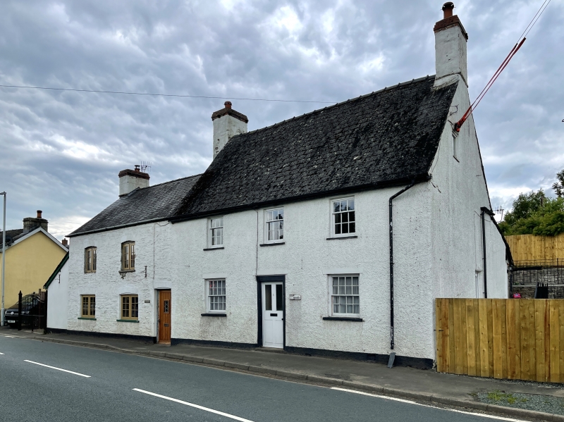
Location: Located immediately S of the centre of the village, at the end of a row of two, and detached on the right. At one time an inn or 'beer-house'.

County: Powys

Community: Bronllys

Community: Bronllys

Locality: Llyswen

Traditional County: Brecknockshire

Tagged with: House

Find accommodation in
Bronllys

Exterior

Exterior: Early-mid C19. Colourwashed pebbledash on stone. Slate roof. Two storeys and attic, 3 bays with gable stacks at the N end, the S gable attached to The White House. Central 4-panelled door, the upper panels glazed, hung on heavy frame. Sixteen-paned sash window to ground floor, 9-pane sashes to first floor. Later lean-to extension to rear containing the kitchen.
Included as a well preserved example of substantial earlier C19 building, prominently sited within the village.

External Links

External links are from the relevant listing authority and, where applicable, Wikidata. Wikidata IDs may be related buildings as well as this specific building. If you want to add or update a link, you will need to do so by editing the Wikidata entry.

Recommended Books

Other nearby listed buildings

  • II Griffin Inn
    Located at the turn of the A.470 Builth to Brecon road in the centre of Llyswen village.
  • II Church of St. Gwendoline
    Located immediately NE of the centre of the village, approximately 60m from the A.470.
  • II Lower House Farmhouse
    A farmhouse set at right angles to the road, backing on to the farmyard to the NW.
  • II Llyswen Presbyterian Church
    Located within its own linear churchyard, alongside the main Builth to Crickhowell Road, just beyond the S end of Llyswen village. The churchyard has a stone wall with a gate opening along the road f
  • II Boughrood Bridge
    Located off the A.470 N of Llyswen village, and forming the major bridge across the Wye between Glasbury and Erwood.
  • II Toll Cottage at Boughrood Bridge
    Located on the SE side of Boughrood Bridge, at the Radnorshire end of the crossing to Brecknockshire
  • II* Y Dderw
    Located at the head of the driveway off the main Llyswen to Hay road, on level ground in the floodplain of the River Wye.
  • II Barn at W side of farmyard at Y Dderw
    The barn lies at the W end of the farmyard, SSW of Y Dderw.

BritishListedBuildings.co.uk is an independent online resource and is not associated with any government department. All government data published here is used under licence. Please do not contact BritishListedBuildings.co.uk for any queries related to any individual listed building, planning permission related to listed buildings or the listing process itself.

British Listed Buildings is a Good Stuff website.