Approximate Location Map
Large Map »
Latitude: 51.7371 / 51°44'13"N
Longitude: -4.3084 / 4°18'30"W
OS Eastings: 240703
OS Northings: 206792
OS Grid: SN407067
Mapcode National: GBR GP.BRMC
Mapcode Global: VH3M2.8LPN
Plus Code: 9C3QPMPR+VJ
Entry Name: Morfa House
Listing Date: 28 July 1998
Last Amended: 28 July 1998
Grade: II
Source: Cadw
Source ID: 20185
Building Class: Domestic
ID on this website: 300020185
Location: Situated in terraced row on main road (A 484) some 40m S of Kidwelly Bridge.
County: Carmarthenshire
Town: Kidwelly
Community: Kidwelly (Cydweli)
Community: Kidwelly
Locality: Kidwelly/Cydweli
Built-Up Area: Kidwelly
Traditional County: Carmarthenshire
Tagged with: Building
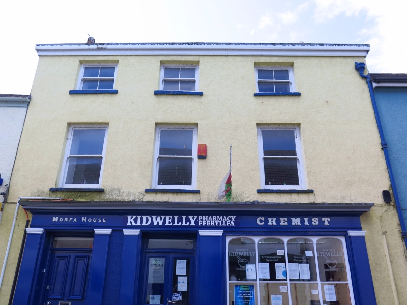
Early C19 house with later C19 shop front.
Pebbledash with slate roof and rendered end stacks. Three-storey, three-window range, off-set to left, with painted timber cornice and low parapet. Later C19 or C20 horned sashes, 4-pane square to upper floor, plate-glass to first floor, all with stone sills. Ground floor has fine Victorian painted timber shopfront with pilasters and overall entablature with cornice. Fascia lettering in raised capitals, painted to imitate marble: 'Morfa House' to left, and 'Chemist' to right. Pilasters frame house door to left, 4-panel with overlight, then three more pilasters frame shop door and window. Deeply recessed half-glazed shop door with overlight, aligned with centre windows above. Shop-window to right, 4-light with mid transom and elliptical-arched heads to lights. Pilaster between the shop window and shop door is broader than the others. Pilasters have plain stucco plinths and moulded caps.
Iron columns inside shop.
Listed as a good late Georgian facade with rare complete Victorian shopfront.
External links are from the relevant listing authority and, where applicable, Wikidata. Wikidata IDs may be related buildings as well as this specific building. If you want to add or update a link, you will need to do so by editing the Wikidata entry.


Other nearby listed buildings
