Approximate Location Map
Large Map »
Latitude: 52.9282 / 52°55'41"N
Longitude: -3.0626 / 3°3'45"W
OS Eastings: 328668
OS Northings: 337285
OS Grid: SJ286372
Mapcode National: GBR 73.MDLK
Mapcode Global: WH78C.XNTJ
Plus Code: 9C4RWWHP+7X
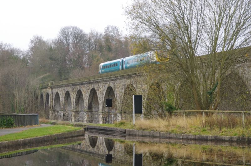
Entry Name: Railway Viaduct over River Ceiriog
Listing Date: 29 July 1998
Last Amended: 29 July 1998
Grade: II*
Source: Cadw
Source ID: 20210
Building Class: Transport
Also known as: Chirk Railway Viaduct
ID on this website: 300020210
Location: The viaduct crosses the valley parallel to Chirk Aqueduct, 550m SW of the Church at the centre of the village.
County: Wrexham
Town: Wrexham
Community: Chirk (Y Waun)
Community: Chirk
Locality: Ceiriog
Traditional County: Denbighshire
Lieutenancy Area (Ceremonial County): Shropshire
Tagged with: Railway viaduct
The viaduct was built to the design of Henry Robinson, chief engineer to the Shrewsbury to Chester Railway, in 1846-1848, Thomas Brassey being the general contractor. The Shrewsbury Chester line was initiated by 'King' Robinson, who had received his training under George Stephenson, and who recognised the need, not met by the canals, to transport materials to Wrexham and Chester. Robinson's survey had in part to be undertaken at night due to the hositility of Col Robert Myddleton-Biddulph of Chirk Castle. The line became part of the Great Western Railway system in 1854.
Built of coursed squared rock-faced stone, the upper arch stage of brick faced with stone. It is approximately 260m (849ft) long, comprising 16 arches, ten forming the major span, rising 30m (100ft) above the river, and 3 each end, built at first in wood, and replaced in stone in 1858. The main piers are tapered upwards to the an ashlar fascia and torus moulding on the springing line, above which there are decorative arched niches with architraves, keystones and pediments. The arches between piers have ashlar voussoirs backed to course, with a dropped keystone. Modillion cornice below the ashlar parapet.
Included at II* as an important example of railway engineering of the mid C19, and of group value with Chirk Aqueduct.
External links are from the relevant listing authority and, where applicable, Wikidata. Wikidata IDs may be related buildings as well as this specific building. If you want to add or update a link, you will need to do so by editing the Wikidata entry.


Other nearby listed buildings
