Approximate Location Map
Large Map »
Latitude: 53.1954 / 53°11'43"N
Longitude: -4.3752 / 4°22'30"W
OS Eastings: 241423
OS Northings: 369112
OS Grid: SH414691
Mapcode National: GBR 5C.2RND
Mapcode Global: WH42Z.RYR7
Plus Code: 9C5Q5JWF+5W
Entry Name: Railway Viaduct north of Malltraeth
Listing Date: 3 September 1998
Last Amended: 3 September 1998
Grade: II
Source: Cadw
Source ID: 20408
Building Class: Transport
Also known as: Malltraeth Viaduct
ID on this website: 300020408
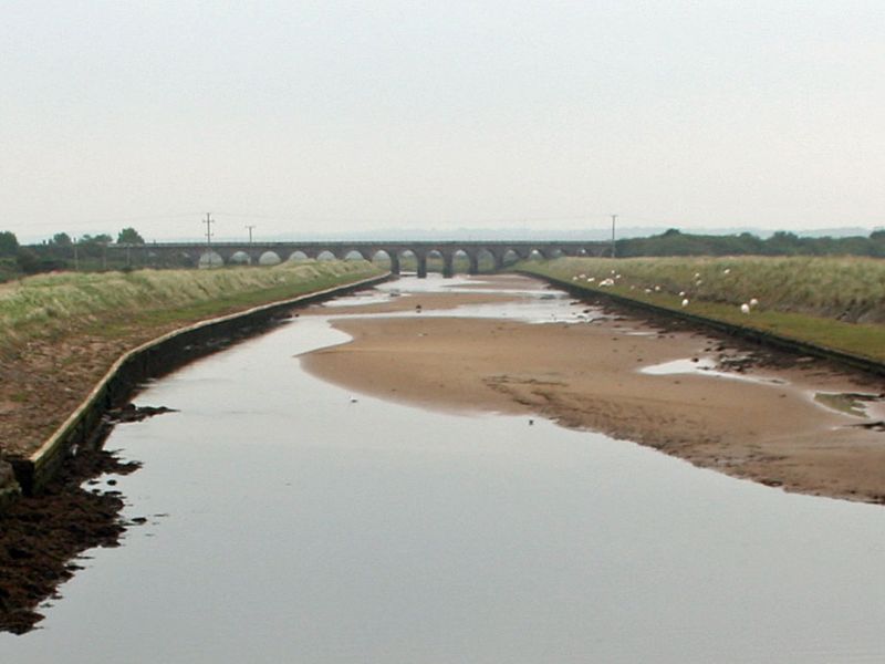
Location: Carrying the main Chester to Holyhead railway line over the Afon Cefni and flanking stretches of land across the Malltraeth Marsh; c. 750m NE of Malltraeth.
County: Isle of Anglesey
Community: Bodorgan
Community: Bodorgan
Locality: Malltraeth
Tagged with: Viaduct Railway viaduct
The Chester to Holyhead railway was proposed to improve links between London and Dublin. The bill was passed in July 1844, with Robert Stephenson as engineer and Francis Thompson of Derby as architect. The earliest work on the line took place on the stretches running through Llangaffo and Trefdraeth parishes, during the summer of 1845; the main contractor was Edward Ladd Betts who came to reside at Aber Braint while work was in progress. The line was opened on 31st March 1848 when the first train made the journey from Llanfairpwllgwyngyll to Holyhead.
Railway viaduct of 19 low spans, each a voussoir arch. Built of rusticated limestone masonry laid to diminishing courses; plain dressed parapet over a stressed cornice. Each arch now with internal concrete structural linings.
Included as an important structural component of the Chester to Holyhead railway, and a prominent landscape feature within the surrounding areas of reclaimed marshland. A bold design using masonry detailing to give the impression of solidity and permanence.
External links are from the relevant listing authority and, where applicable, Wikidata. Wikidata IDs may be related buildings as well as this specific building. If you want to add or update a link, you will need to do so by editing the Wikidata entry.


Other nearby listed buildings
