Approximate Location Map
Large Map »
Latitude: 51.5353 / 51°32'7"N
Longitude: -3.2605 / 3°15'37"W
OS Eastings: 312669
OS Northings: 182573
OS Grid: ST126825
Mapcode National: GBR HT.GJL6
Mapcode Global: VH6DZ.FNNX
Plus Code: 9C3RGPPQ+4R
Entry Name: Ynys Bridge
Listing Date: 31 January 2000
Last Amended: 31 January 2000
Grade: II
Source: Cadw
Source ID: 22823
Building Class: Transport
Also known as: Ynys Bridge (partly in Pentyrch community)
ID on this website: 300022823
Location: Between Tongwynlais and Garth Wood, now by-passed by a new bridge close by to N.
County: Cardiff
Community: Pentyrch
Community: Pentyrch
Locality: Taff Vale
Built-Up Area: Taff's Well
Traditional County: Glamorgan
Tagged with: Bridge
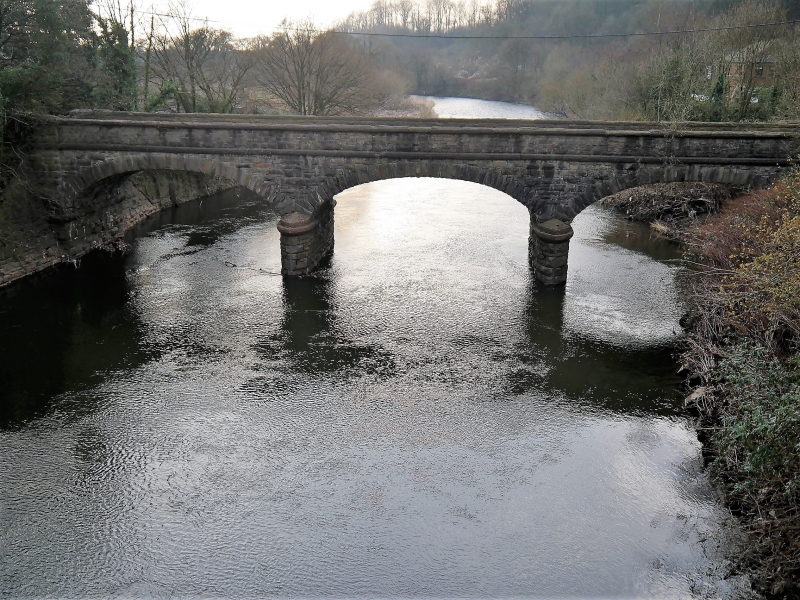
Associated with the Pentyrch and Melingriffith works on the W bank of the Taff. Ironworks had been developed in the area in C16. By 1803 they were described as an area of extensive collieries abounding in iron ore. Melingriffith furnace rebuilt 1815, second furnace built 1830. Works described as comprising collieries, limestone quarries, brickworks, coke ovens, foundries, forges, 3 melling furnaces, 9 fineries...fitting shops, smiths, millwrights, pattern making shops. Failed in 1888 with introduction of steel. Site shown on first edition OS map immediately N of bridge; by late C20 completely cleared and redeveloped. On this map called Castle Coch Bridge. Style of masonry comparable to railway bridges of c 1860. The bridge provided important access to the main N/S thoroughfare on the E bank of the River Taff.
Parapet of snecked rockfaced stone with giant coping stones of Radyr stone, a red conglomerate, roughly hewn; further band of Radyr stone at base of parapet. 2 narrow cutwater piers with moulded bands protruding beyond width of bridge either side, 3 wide elliptical arches with rough voussoirs, with pointed ends where not truncated against parapet and with a tooled edge.
Included as an unaltered mid C19 bridge with close connections to the historic Pentyrch/Melingriffith ironworking site.
External links are from the relevant listing authority and, where applicable, Wikidata. Wikidata IDs may be related buildings as well as this specific building. If you want to add or update a link, you will need to do so by editing the Wikidata entry.


Other nearby listed buildings
