History in Structure

Carn Ingli

A Grade II Listed Building in Lisvane, Cardiff

More Photos »
Approximate Location Map
Large Map »

Coordinates

Latitude: 51.5395 / 51°32'22"N

Longitude: -3.1669 / 3°10'0"W

OS Eastings: 319165

OS Northings: 182939

OS Grid: ST191829

Mapcode National: GBR HY.GB3H

Mapcode Global: VH6F1.2K4N

Plus Code: 9C3RGRQM+R6

Entry Name: Carn Ingli

Listing Date: 28 April 2000

Last Amended: 28 April 2000

Grade: II

Source: Cadw

Source ID: 23228

Building Class: Domestic

ID on this website: 300023228

Location: Near the centre of the village, SW of the church and along the main road from Ty Gwyn mansion.

County: Cardiff

Town: Cardiff

Community: Lisvane (Llys-faen)

Community: Lisvane

Built-Up Area: Cardiff

Traditional County: Glamorgan

Tagged with: Architectural structure

Find accommodation in
Lisvane

History

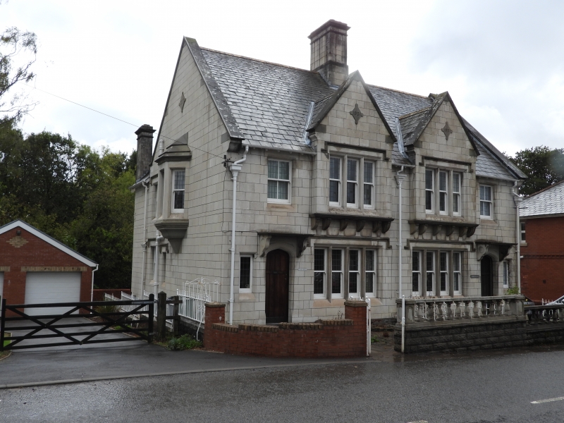
Datestone 1931 and inscription JET denotes builder as J E Turner, the well-known Cardiff firm of builders (generally trading as E Turner and Sons) responsible for many of Cardiff's public buildings in Cathays Park. In 1906 they had built a house nearby, Ty Gwyn, for their personal use.

Reasons for Listing

Included for their architectural interest as an exceptional pair of Portland stone houses built by the farmous Cardiff builders, E Turner and Sons, in the inter War period.

External Links

External links are from the relevant listing authority and, where applicable, Wikidata. Wikidata IDs may be related buildings as well as this specific building. If you want to add or update a link, you will need to do so by editing the Wikidata entry.

Recommended Books

Other nearby listed buildings

  • II Cerrig Llwyd
    Near the centre of the village, SW of the church and along the main road from Ty Gwyn mansion.
  • II* Church of St Denys
    On the very E edge of the developed part of Lisvane.
  • II Coach House at Ty Gwyn
    To the E of Ty Gwyn, set below on a bend in the private entrance drive.
  • II Ty Gwyn
    In the S part of Lisvane, on the edge of the developed area overlooking the meadows of Coetgae-sych, surrounded by elaborate terraced grounds and reached by a drive.
  • II Lisvane House
    Towards the top of the rise in Mill Road with gardens to side and rear.
  • II Pant-teg (aka Panteg)
    In a hollow by the stream Nant y Draenog, surrounded by farmland and reached by a track from B4562.
  • II The Dingle
    Near the upper end of Mill Road, set in its own gardens reached by a short drive.
  • II Glan-y-nant
    About 200m north of motorway, at extreme west edge of the community.

BritishListedBuildings.co.uk is an independent online resource and is not associated with any government department. All government data published here is used under licence. Please do not contact BritishListedBuildings.co.uk for any queries related to any individual listed building, planning permission related to listed buildings or the listing process itself.

British Listed Buildings is a Good Stuff website.