Approximate Location Map
Large Map »
Latitude: 53.0081 / 53°0'29"N
Longitude: -3.4438 / 3°26'37"W
OS Eastings: 303220
OS Northings: 346617
OS Grid: SJ032466
Mapcode National: GBR 6L.GHY8
Mapcode Global: WH77T.2NC9
Plus Code: 9C5R2H54+6F
Entry Name: The Hand
Listing Date: 7 August 2000
Last Amended: 7 August 2000
Grade: II
Source: Cadw
Source ID: 23872
Building Class: Domestic
ID on this website: 300023872
Location: In the village of Bettws Gwerfil Goch, north west of the church, immediately backing on to the churchyard.
County: Denbighshire
Town: Corwen
Community: Betws Gwerfil Goch (Betws Gwerful Goch)
Community: Betws Gwerfil Goch
Locality: Bettws Gwerfil Goch
Traditional County: Merionethshire
Tagged with: Building
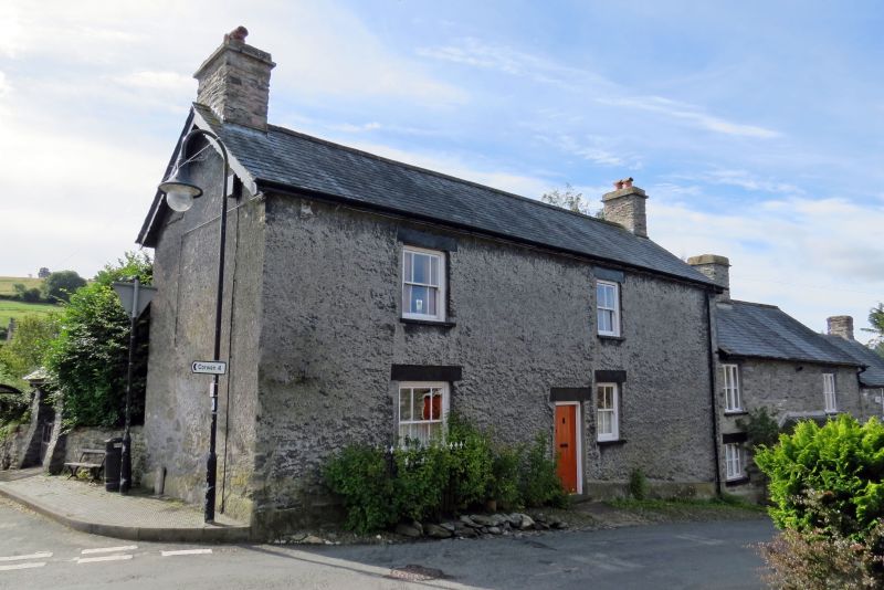
A public house probably of the late C18 or early C19, though the prominence of the site on a main thoroughfare may suggest an earlier origin. The house stands on a confined site between the street and the churchyard; its brewhouse stood on the other side of the road.
In the period immediately before the Great War the village of Bettws Gwerfil Goch was a notable centre of Gypsy activity in north Wales, especially concentrated at the two public houses, but mainly the Hand. These people were locally in contact with a number of artistic and literary figures from Liverpool University in the Gypsy Lore Society, including Dr Sampson, the university libararian, and Augustus John, the artist.
The house stands on a corner site, facing west to the principal road through the village; the building is of two storeys, in local axe-dressed masonry, with the front and end walls facing the streets rendered. Slate roof with moderate overhang at eaves and verges; decorative bargeboards; stone end-chimneys.
The front elevation has a tendency to symmetry with six-pane sash windows above and below to left, and four-pane sash windows above and below to right; but boarded front door strongly offset to the right. All openings have thick stone lintels. Small railed enclosure at the left window, stone path and steps to the main door; border of pitched stone paving. The rear elevation facing the churchyard is asymmetrical, with two windows above and below confined to the south unit of the house; the presumed original parlour unit, to the north, having a blind back.
Not inspected.
A well-preserved former village public house which has retained its character. The house has significant historical associations with Romanies, and forms part of a group at the centre of the village.
External links are from the relevant listing authority and, where applicable, Wikidata. Wikidata IDs may be related buildings as well as this specific building. If you want to add or update a link, you will need to do so by editing the Wikidata entry.


Other nearby listed buildings
