Approximate Location Map
Large Map »
Latitude: 51.6068 / 51°36'24"N
Longitude: -2.9174 / 2°55'2"W
OS Eastings: 336566
OS Northings: 190171
OS Grid: ST365901
Mapcode National: GBR J9.9T16
Mapcode Global: VH7B7.DW13
Plus Code: 9C3VJ34M+P3
Entry Name: Barn at Priory Farm
Listing Date: 18 January 2002
Last Amended: 18 January 2002
Grade: II
Source: Cadw
Source ID: 26132
Building Class: Agriculture and Subsistence
ID on this website: 300026132
Location: In the farmyard of Priory Farm about 50m south of the farmhouse and close under the embankment of the A449.
County: Newport
Town: Newport
Community: Caerleon (Caerllion)
Community: Caerleon
Locality: Christchurch
Built-Up Area: Newport
Traditional County: Monmouthshire
Tagged with: Barn
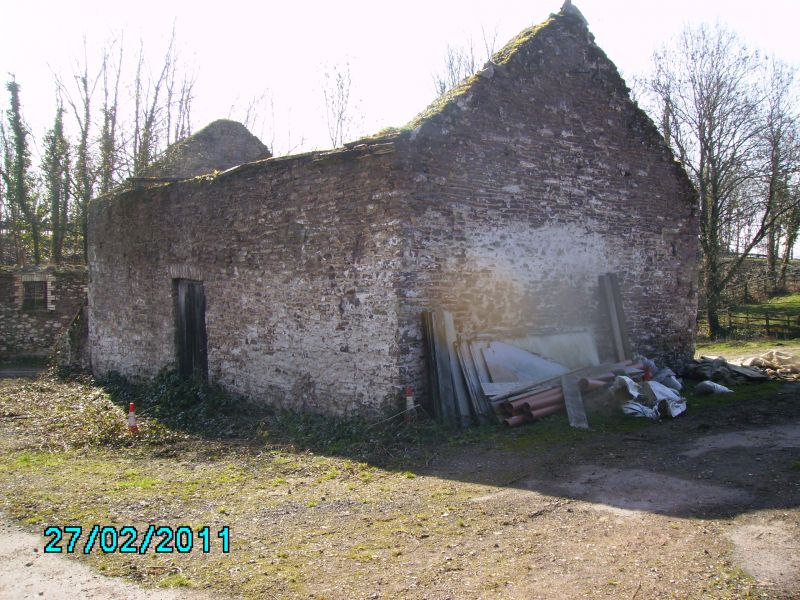
This barn dates probably from the early C19 and is contemporary with the refurbishment of Priory Farmhouse at that time.
The barn is built from limewashed local sandstone rubble with a Welsh slate roof. It is a combination building with stable and hayloft to the north and threshing barn to the south with a lean-to pigsty at the south gable end. The west front has central plank doors to the threshing floor going right to the eaves. To the left is a plain plank door to the stable with a pointed head window to the left of that. Above is a taking-in door to the hayloft. To the right are two small square vents. The left gable has small vents, the right gable has a slit vent with double pigsty below this. The east elevation has a small door to the threshing floor and two small square vents above to the left.
The interior was not available for inspection at resurvey but is very likely to be unaltered.
Included as an unaltered early C19 barn having group value with Priory Farmhouse.
External links are from the relevant listing authority and, where applicable, Wikidata. Wikidata IDs may be related buildings as well as this specific building. If you want to add or update a link, you will need to do so by editing the Wikidata entry.


Other nearby listed buildings
