Approximate Location Map
Large Map »
Latitude: 51.8133 / 51°48'47"N
Longitude: -2.711 / 2°42'39"W
OS Eastings: 351079
OS Northings: 212975
OS Grid: SO510129
Mapcode National: GBR FL.WVJH
Mapcode Global: VH86T.YPNB
Plus Code: 9C3VR77Q+8H
Entry Name: 14, St. James's Street
Listing Date: 10 August 2005
Last Amended: 10 August 2005
Grade: II
Source: Cadw
Source ID: 85032
ID on this website: 300085032
Location: Prominently sited within the main group of historic buildings on the east side of Monmouth and about 300m east of the town square.
County: Monmouthshire
Town: Monmouth
Community: Monmouth (Trefynwy)
Community: Monmouth
Built-Up Area: Monmouth
Traditional County: Monmouthshire
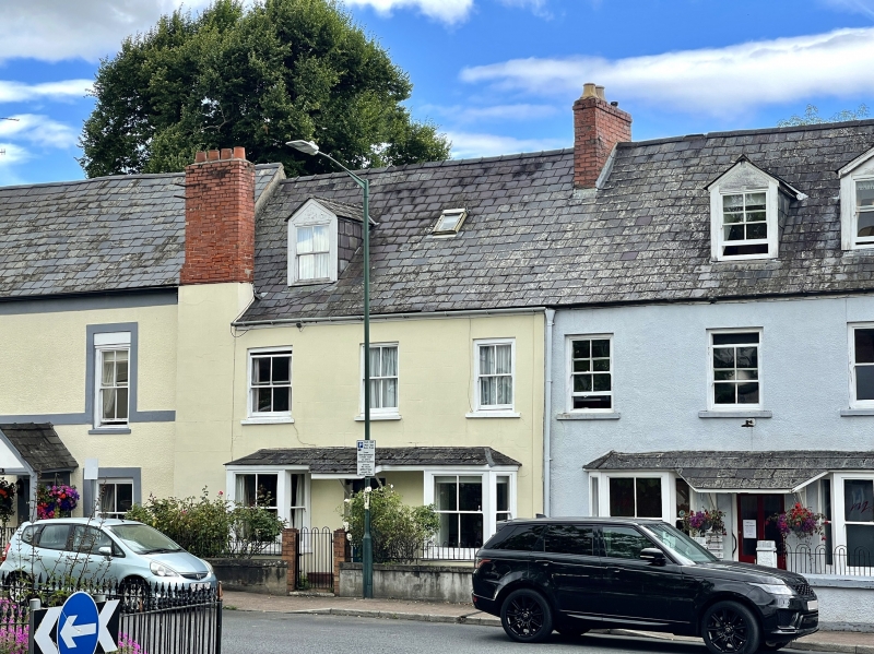
A possibly c1600 house with its external treatment dating from the C19. It was one property together with No. 16 when a garage between the wars and was then divided into two houses with the resulting changes.
Rendered and painted front with a Welsh slate roof and red brick stacks. Main range parallel with street, and rear outshut. Two storeys and attic, three windows. Central entrance with part glazed door and a hood/porch which is continuous with the roofs of the flanking canted bays which have 2 over 2 pane sashes flanked by 1 over 1. The right hand bay is a post WWII addition after the conversion of the garage to two house (see History). The first floor has later C19 2 over 2 pane sashes; single gabled dormer in roof; large lateral stack to left side, ridge stack to right. Rear elevation not seen.
The house has been very altered internally and no ancient features were seen at resurvey except for possibly C17 beams and principal rafters which are all boxed-in.
Included for its special architectural interest as a multi-period building of definite character near Monmouth town centre.
External links are from the relevant listing authority and, where applicable, Wikidata. Wikidata IDs may be related buildings as well as this specific building. If you want to add or update a link, you will need to do so by editing the Wikidata entry.


Other nearby listed buildings
