Approximate Location Map
Large Map »
Latitude: 50.3864 / 50°23'10"N
Longitude: -3.579 / 3°34'44"W
OS Eastings: 287844
OS Northings: 55245
OS Grid: SX878552
Mapcode National: GBR QS.P441
Mapcode Global: FRA 38D0.TRN
Plus Code: 9C2R9CPC+GC
Entry Name: Farm Buildings Immediately East of Greenway Farmhouse
Listing Date: 21 May 1985
Grade: II
Source: Historic England
Source ID: 1146677
English Heritage Legacy ID: 100579
ID on this website: 101146677
Location: South Hams, Devon, TQ5
County: Devon
District: South Hams
Civil Parish: Kingswear
Traditional County: Devon
Lieutenancy Area (Ceremonial County): Devon
Church of England Parish: Churston Ferrers St Mary the Virgin
Church of England Diocese: Exeter
Tagged with: Agricultural structure
SX 85 NE KINGSWEAR GREENWAY ROAD
8/149 Farm buildings
immediately east of
- Greenway Farmhouse
- II
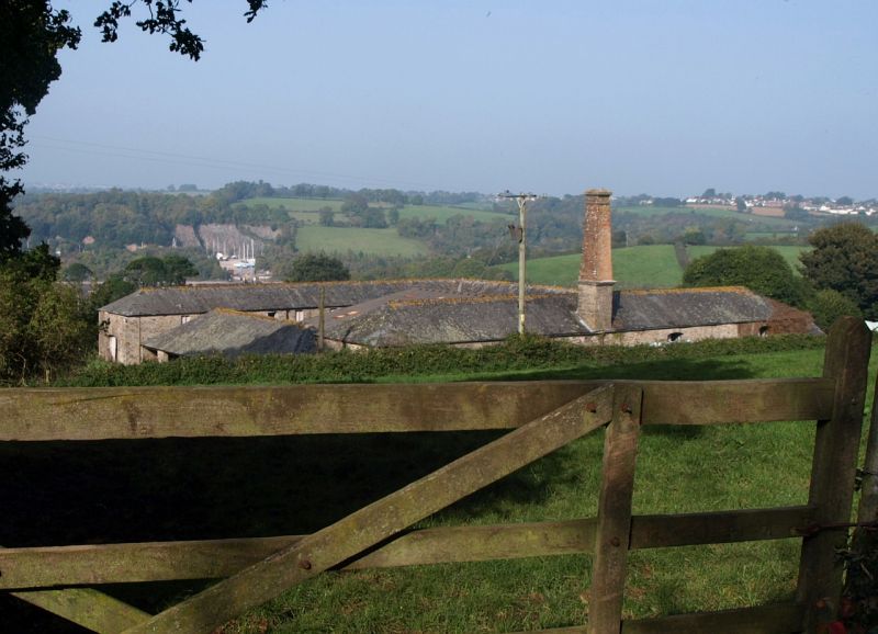
Planned range of contemporary farm buildings. Circa 1850 and probably contem-
porary with Greenway Farmhouse qv. Stone rubble with dressed stone quoins and
arches. Low pitched slate hipped roofs. Continuous two storey ranges planned
around three sides of a stock yard with a detached single storey cattle shelter
and cartshed on the fourth side. Now has a C20 covered yard inserted but not
physically affecting the original buildings. Long bank barn on the south side
with four segmentally arched first floor barn doors on the outside wall and large
steam engine chimney stack rising from the centre of the outer wall, with square
plan stone rubble pedestal with moulded stone cornice and square red brick shaft
with projecting brick cap. All machinery taken out. Barn range has loading
doors and windows over doorway and windows below, and a segmentally arched wagon
entrance on west end to root house. The east range of stables and beef fattening
house has lofts above. The north range is shippen with lofts over and root house
in end with segmental arched wagon entrance. All segmentally arched openings
with plank doors and shutters. Detached range on fourth (west) side, single
storey with single span hipped roof. Open-fronted cattle shelter to yard with
cast iron posts supporting roof. Wagon and implement sheds facing outwards,
right hand open fronted with stone pier, left hand with boarded double doors.
A good and complete example of a planned farmstead of the high farming period.
Listing NGR: SX8784455245
External links are from the relevant listing authority and, where applicable, Wikidata. Wikidata IDs may be related buildings as well as this specific building. If you want to add or update a link, you will need to do so by editing the Wikidata entry.


Other nearby listed buildings
