Approximate Location Map
Large Map »
Latitude: 50.3919 / 50°23'30"N
Longitude: -3.7029 / 3°42'10"W
OS Eastings: 279051
OS Northings: 56056
OS Grid: SX790560
Mapcode National: GBR QL.PVSJ
Mapcode Global: FRA 3840.F7V
Plus Code: 9C2R97RW+QV
Entry Name: Crowdy Mill
Listing Date: 30 August 1988
Grade: II
Source: Historic England
Source ID: 1215944
English Heritage Legacy ID: 101336
ID on this website: 101215944
Location: Harbertonford, South Hams, Devon, TQ9
County: Devon
District: South Hams
Civil Parish: Harberton
Traditional County: Devon
Lieutenancy Area (Ceremonial County): Devon
Church of England Parish: Harbertonford St Peter
Church of England Diocese: Exeter
Tagged with: Mill
HARBERTON
5X7856-5X7956
15/349 HARBERTON FORD
30.8.88 Crowdy Mill
GV
II
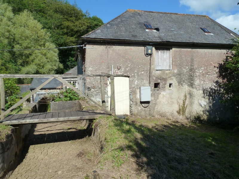
Water mill in working order and adjoining mill house on Harbourne River.
Circa late C17 or early C18, possibly with earlier origins, enlarged in about
1840s and the mill raised by one storey and re-roofed in 1900. Restored to
working order 1982-4.
Local stone and slate rubble. Mill heightened in rendered brick. Mill house
has slurried scantle slate hipped roof. Mill has slate roof at higher level,
hipped at south end and slate hung gable at east end. Rendered ridge stack
with slate weathering and slate hung stack on east side.
Plan: The original C17 to C18 mill and mill house was L-shaped on plan with
the mill to the left (west) with a projecting wing to the front (south) which
was extended after 1840. The mill house to the right (east) was extended by
one bay and enlarged to double depth plan to the rear (north) with a stack on
the side wall. A lower wing was added at the rear in C19, after 1840 (not on
tithe map). The ridge stack is the original gable end stack before the
extension was added. There is a small lower gable-ended wing to the north
of the C19 extension and a hipped roof single storey outshut in the angle.
Exterior: 2 storey house. 2 window range. C20 casements in original
openings. Left hand with slated lintels, right hand with flat stone arches.
Central glazed door with large rebuilt early C20 glazed porch with cast iron
finial and crested ridge tiles.
Mill to left (west). 2 storeys, heightened to 3 storeys in rendered brick.
L-shaped on plan with projecting wing which has a doorway in the end wall and
first floor door above with hoist. Small window openings on south and east
sides with C20 2-light casements with glazing bars. Doorway to first floor
from higher ground level on west side with small ventilation hole to right
with chamfered slate lintel and loft door above.
Interior: Roof of mill house has C19 nailed trusses and mill has circa 1900
roof. Machinery; restored working machinery. 2 overshot wheels, on north
side, turn in opposite directions. Upper wheel turns 2 sets of mill stones
through spur gearing and also drive ancilliary machinery. Lower water wheel
drive single set of mill stones. Lower machinery is lay shot drive.
Reference: Martin Watts. Industrial Archaeology, vol 17 no 1, spring 1984,
pp 47 to 51.
Listing NGR: SX7905156056
External links are from the relevant listing authority and, where applicable, Wikidata. Wikidata IDs may be related buildings as well as this specific building. If you want to add or update a link, you will need to do so by editing the Wikidata entry.


Other nearby listed buildings
