Approximate Location Map
Large Map »
Latitude: 50.9208 / 50°55'15"N
Longitude: -2.3455 / 2°20'43"W
OS Eastings: 375809
OS Northings: 113544
OS Grid: ST758135
Mapcode National: GBR 0X4.1V9
Mapcode Global: FRA 56ZN.VDD
Plus Code: 9C2VWMC3+8Q
Entry Name: Bagber Cottage
Listing Date: 20 October 1983
Grade: II
Source: Historic England
Source ID: 1110564
English Heritage Legacy ID: 102383
ID on this website: 101110564
Location: Bagber, Dorset, DT10
County: Dorset
Civil Parish: Sturminster Newton
Traditional County: Dorset
Lieutenancy Area (Ceremonial County): Dorset
Church of England Parish: Sturminster Newton St Mary
Church of England Diocese: Salisbury
Tagged with: Cottage
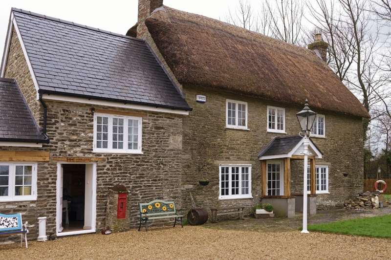
ST 71 SE STURMINSTER NEWTON BAGBER
4/70 Bagber Cottage
II
House, probably mid C18. Coursed rubble, thatched with gable ends and
end stone stacks. 2 storeys, 3 window range.2 and 3-light C20 wooden
casements with glazing bars. C20 porch. Concrete lintels to ground floor
windows "RCHM Dorset, Vol III", HMSO, 1970, p285 No67.
Listing NGR: ST7580913544
External links are from the relevant listing authority and, where applicable, Wikidata. Wikidata IDs may be related buildings as well as this specific building. If you want to add or update a link, you will need to do so by editing the Wikidata entry.


Other nearby listed buildings
