Approximate Location Map
Large Map »
Latitude: 51.0346 / 51°2'4"N
Longitude: -2.2667 / 2°16'0"W
OS Eastings: 381396
OS Northings: 126173
OS Grid: ST813261
Mapcode National: GBR 0VW.3RD
Mapcode Global: FRA 664C.W7N
Plus Code: 9C3V2PMM+R8
Entry Name: Lodden Bridge Farmhouse
Listing Date: 3 January 1985
Grade: II
Source: Historic England
Source ID: 1324573
English Heritage Legacy ID: 102987
ID on this website: 101324573
Location: Gillingham, Dorset, SP8
County: Dorset
Civil Parish: Gillingham
Built-Up Area: Gillingham
Traditional County: Dorset
Lieutenancy Area (Ceremonial County): Dorset
Church of England Parish: Gillingham St Mary the Virgin
Church of England Diocese: Salisbury
Tagged with: Farmhouse
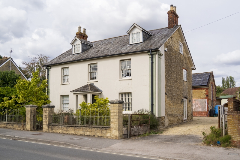
ST 82 NW GILLINGHAM SHAFTESBURY ROAD
3/148 Lodden Bridge Farmhouse
- II
Farmhouse, early to mid C19. Colourwashed, rendered walls with end
pilaster strips. Hipped slate roof with end brick stacks. 2 storeys,
3 bays, symmetrical. Sashes with glazing bars. Central part-glazed
door.
Listing NGR: ST8139626173
External links are from the relevant listing authority and, where applicable, Wikidata. Wikidata IDs may be related buildings as well as this specific building. If you want to add or update a link, you will need to do so by editing the Wikidata entry.


Other nearby listed buildings
