Approximate Location Map
Large Map »
Latitude: 51.038 / 51°2'16"N
Longitude: -2.2826 / 2°16'57"W
OS Eastings: 380283
OS Northings: 126556
OS Grid: ST802265
Mapcode National: GBR 0VN.ZP1
Mapcode Global: FRA 663C.NLB
Plus Code: 9C3V2PQ8+6X
Entry Name: Old Toll House
Listing Date: 3 January 1985
Grade: II
Source: Historic England
Source ID: 1324575
English Heritage Legacy ID: 102996
ID on this website: 101324575
Location: Cold Harbour, Dorset, SP8
County: Dorset
Civil Parish: Gillingham
Built-Up Area: Gillingham
Traditional County: Dorset
Lieutenancy Area (Ceremonial County): Dorset
Church of England Parish: Gillingham St Mary the Virgin
Church of England Diocese: Salisbury
Tagged with: House
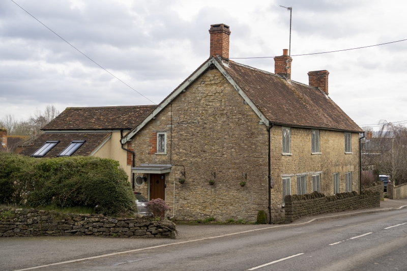
ST 8026 GILLINGHAM WYKE ROAD
12/157 Old Toll House
- II
Cottage, probably late C18. Coursed rubble with tiled, gable-ended
roof with end stone stacks. 2 storeys, 3 irregular window range.
2-light casements with diamond pane leaded-lights in iron frames.
Front door is now blocked and entrance to the house is from the side.
Listing NGR: ST8028326556
External links are from the relevant listing authority and, where applicable, Wikidata. Wikidata IDs may be related buildings as well as this specific building. If you want to add or update a link, you will need to do so by editing the Wikidata entry.


Other nearby listed buildings
