Approximate Location Map
Large Map »
Latitude: 50.9299 / 50°55'47"N
Longitude: -2.191 / 2°11'27"W
OS Eastings: 386669
OS Northings: 114512
OS Grid: ST866145
Mapcode National: GBR 1YG.QVK
Mapcode Global: FRA 669N.86N
Plus Code: 9C2VWRH5+XH
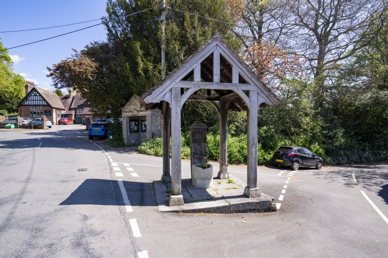
Entry Name: Village Pump and Pumphouse
Listing Date: 24 June 1985
Grade: II
Source: Historic England
Source ID: 1110195
English Heritage Legacy ID: 103226
ID on this website: 101110195
Location: Iwerne Minster, Dorset, DT11
County: Dorset
Civil Parish: Iwerne Minster
Built-Up Area: Iwerne Minster
Traditional County: Dorset
Lieutenancy Area (Ceremonial County): Dorset
Church of England Parish: Iwerne Minster St Mary
Church of England Diocese: Salisbury
Tagged with: Well Pumping station
ST 8614 IWERNE MINSTER HIGHER STREET
10/136 Village Pump and Pumphouse
GV II
Village pump and pumphouse dated 'W 1880'. Open timber pumphouse with
pitched, tiled roof. Stone base. Pump encased in wooden housing. An
important part of the street scene. Probably built for Lord Wolverton.
Listing NGR: ST8666714529
External links are from the relevant listing authority and, where applicable, Wikidata. Wikidata IDs may be related buildings as well as this specific building. If you want to add or update a link, you will need to do so by editing the Wikidata entry.


Other nearby listed buildings
