Approximate Location Map
Large Map »
Latitude: 50.8528 / 50°51'10"N
Longitude: -2.1671 / 2°10'1"W
OS Eastings: 388336
OS Northings: 105934
OS Grid: ST883059
Mapcode National: GBR 1ZG.JXW
Mapcode Global: FRA 66BV.CKX
Plus Code: 9C2VVR3M+45
Entry Name: Lodge, Gateway and Flanking Walls to Bryanston School Approximately 60 Metres North West of the Stour Inn
Listing Date: 14 July 1955
Last Amended: 11 June 1985
Grade: II
Source: Historic England
Source ID: 1171846
English Heritage Legacy ID: 103307
ID on this website: 101171846
Location: Blandford St Mary, Dorset, DT11
County: Dorset
Civil Parish: Bryanston
Built-Up Area: Blandford Forum
Traditional County: Dorset
Lieutenancy Area (Ceremonial County): Dorset
Church of England Parish: Durweston and Bryanston St Nicholas
Church of England Diocese: Salisbury
Tagged with: Gatehouse
BRYANSTON
LOWER BRYANSTON
ST 88 05
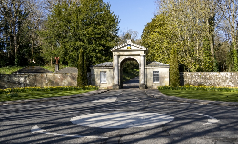
12/31 Lodge, Gateway and
flanking walls to Bryanston
School approximately 60m
14-7-55 north-west of the Stour Inn
(formerly listed as Lodge
to Park).
GV II
Lodge, gateway and flanking walls, c.1778, probably by James Wyatt. Greensand ashlar
with Portland stone dressings, hipped lead roofs. Symmetrical. Central gateway with
round headed arches flanked by single bay, single storey lodges. The central arch is
flanked by Dorie half-columns which support a pedimented entablature. The entablature
bears the inscription 'Bryanston School' in gilded Roman capitals. Each lodge has a
single 12-pane sash and a moulded cornice. The flanking walls curve forward to the
roadside and terminate in large rectangular piers. The walls have moulded copings and
the piers are surmounted by heraldic beasts bearing shields. (RCHM, Dorset, vol.III,
p.47, no.2. Newman J. and Pevsner, N., The Buildings of England: Dorset, 1972, p.118)
Listing NGR: ST8833605934
External links are from the relevant listing authority and, where applicable, Wikidata. Wikidata IDs may be related buildings as well as this specific building. If you want to add or update a link, you will need to do so by editing the Wikidata entry.


Other nearby listed buildings
