Approximate Location Map
Large Map »
Latitude: 50.9008 / 50°54'2"N
Longitude: -2.2488 / 2°14'55"W
OS Eastings: 382597
OS Northings: 111285
OS Grid: ST825112
Mapcode National: GBR 1YS.G80
Mapcode Global: FRA 665Q.HQJ
Plus Code: 9C2VWQ22+8F
Entry Name: Clayton Farmhouse
Listing Date: 11 June 1985
Grade: II
Source: Historic England
Source ID: 1110155
English Heritage Legacy ID: 103339
ID on this website: 101110155
Location: Shillingstone, Dorset, DT11
County: Dorset
Civil Parish: Shillingstone
Built-Up Area: Shillingstone
Traditional County: Dorset
Lieutenancy Area (Ceremonial County): Dorset
Church of England Parish: Shillingstone Holy Rood
Church of England Diocese: Salisbury
Tagged with: Farmhouse
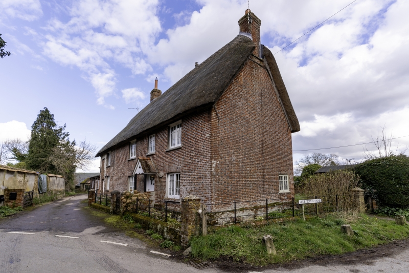
SHILLINGSTONE
ST 8211 CHURCH ROAD
9/63 Clayton Farmhouse
GV II
House, late C18 or early C19. Flemish bond brickwork with some rubble in left
hand extension. Main range symmetrical. 2 storeys, 3 window range. 2-light
casements with glazing bars. Part glazed central plank door in gabled porch.
Ground floor openings under segmental brick heads.
Listing NGR: ST8259711285
External links are from the relevant listing authority and, where applicable, Wikidata. Wikidata IDs may be related buildings as well as this specific building. If you want to add or update a link, you will need to do so by editing the Wikidata entry.


Other nearby listed buildings
