Approximate Location Map
Large Map »
Latitude: 50.7774 / 50°46'38"N
Longitude: -2.1461 / 2°8'45"W
OS Eastings: 389796
OS Northings: 97544
OS Grid: SY897975
Mapcode National: GBR 20G.47L
Mapcode Global: FRA 67D1.1S0
Plus Code: 9C2VQVG3+XH
Entry Name: Village Cross
Listing Date: 14 July 1955
Grade: II
Source: Historic England
Source ID: 1324272
English Heritage Legacy ID: 103611
ID on this website: 101324272
Location: Winterborne Zelston, Dorset, DT11
County: Dorset
Civil Parish: Winterborne Zelston
Built-Up Area: Winterborne Zelston
Traditional County: Dorset
Lieutenancy Area (Ceremonial County): Dorset
Church of England Parish: Winterbourne Zelstone with Tomson and Anderson St Mary
Church of England Diocese: Salisbury
Tagged with: High cross
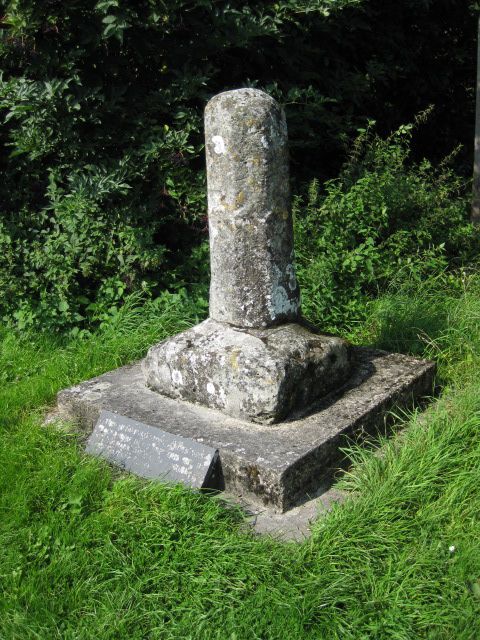
WINTERBORNE ZELSTON
SY 8997 THE STREET (West side)
16/195 Village Cross
14-7-55
II
Base of village cross. Probably medieval. Lower part of octagonal shaft
on square base, raised on square step. Re-sited since original listing -
(was on corner of road opposite its present site).
Listing NGR: SY8980097553
External links are from the relevant listing authority and, where applicable, Wikidata. Wikidata IDs may be related buildings as well as this specific building. If you want to add or update a link, you will need to do so by editing the Wikidata entry.


Other nearby listed buildings
