Approximate Location Map
Large Map »
Latitude: 50.7248 / 50°43'29"N
Longitude: -2.9324 / 2°55'56"W
OS Eastings: 334279
OS Northings: 92098
OS Grid: SY342920
Mapcode National: GBR PJ.CZWJ
Mapcode Global: FRA 47R5.7DP
Plus Code: 9C2VP3F9+W2
Entry Name: The Museum
Listing Date: 31 January 1974
Grade: II
Source: Historic England
Source ID: 1110814
English Heritage Legacy ID: 103790
ID on this website: 101110814
Location: Lyme Regis, Dorset, DT7
County: Dorset
Civil Parish: Lyme Regis
Built-Up Area: Lyme Regis
Traditional County: Dorset
Lieutenancy Area (Ceremonial County): Dorset
Church of England Parish: Lyme Regis St Michael the Archangel
Church of England Diocese: Salisbury
Tagged with: Building
BRIDGE STREET
1.
1357
(South East Side)
The Museum
SY 3492 1/233
11 GV
2.
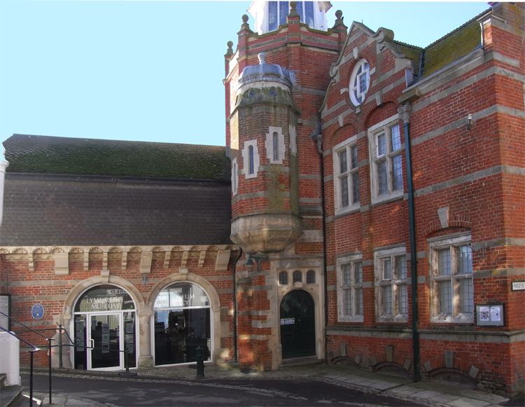
1870 circa; patron Mr Thomas Philpot. L-shaped building of red brick with stone
dressings. Large transomed and mullioned windows with leaded glazing. Gable
end to street has splayed bay windows on ground and 1st floors set within round-headed
recess. Stepped parapet with volutes left hand return of this wing of 3 window
bays; windows in 2 bays set in 3-centred headed recesses surmounted by attic
storey with oval lunette and gable. Projecting stair well set in rear angle
of this wing rising to form an octagonal tower; octagonal lantern with 2-light
window in each facet; rounded roof with tapering finial. An east-west wing of
2 storeys, 2 bays. Loggia on ground floor; 2 stone arches with keystones supported
by stone columns. Modern additions on 1st floor.
From the land, The Museum & Guildhall form a group with Nos 60 to 62 (consec)
Church Street. From the sea, the rear faces of the Museum & Guildhall form a group
with the sea walls at Gun Cliff & with the rear faces of Nos 1 & 2 Broad Street.
Listing NGR: SY3427992098
External links are from the relevant listing authority and, where applicable, Wikidata. Wikidata IDs may be related buildings as well as this specific building. If you want to add or update a link, you will need to do so by editing the Wikidata entry.


Other nearby listed buildings
