Approximate Location Map
Large Map »
Latitude: 50.7249 / 50°43'29"N
Longitude: -2.9322 / 2°55'55"W
OS Eastings: 334297
OS Northings: 92110
OS Grid: SY342921
Mapcode National: GBR PJ.CZZ2
Mapcode Global: FRA 47R5.7HX
Plus Code: 9C2VP3F9+X4
Entry Name: The Guildhall
Listing Date: 23 April 1952
Grade: II*
Source: Historic England
Source ID: 1228691
English Heritage Legacy ID: 103791
ID on this website: 101228691
Location: Lyme Regis, Dorset, DT7
County: Dorset
Civil Parish: Lyme Regis
Built-Up Area: Lyme Regis
Traditional County: Dorset
Lieutenancy Area (Ceremonial County): Dorset
Church of England Parish: Lyme Regis St Michael the Archangel
Church of England Diocese: Salisbury
Tagged with: Gildhouse
BRIDGE STREET
1.
1357
(South East Side)
The Guildhall
SY 3492 1/18 25.4.52.
II* GV
2.
Rebuilt 1887, incorporating early C16 to Cl7 fittings from the previous building.
Inside, and within 1st floor chambers, some Cl7 fittings eg dais-balustrade.
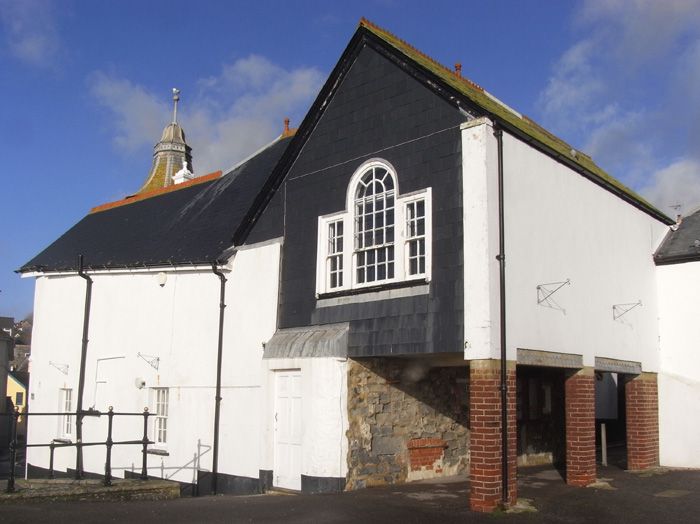
East part of north front of 2 storeys, 3 window bays. Easternmost bay projects
forward with passageway through on ground floor. Venetian window on 1st floor
and round window above with gable over. On 1st floor, to right hand, paired
sash to middle bay and overhanging bay window with gable over to west bay. 2
wide elliptical arches on columns to ground floor; to right hand end, narrower
round headed doorway. To right hand again, a lower 2-storey bay; square grille
on 1st floor; doorway containing original door to Cockmoil on ground floor.
To right hand again, stair tower of flint, circular below, octagonal above with
slate cupola. Before south-west side of tower, flight of steps leads up to round-headed
doorway flanked by pilasters and with gable over. To south-west again, and in
recession, splayed transomed and mullioned oriel window to 1st floor; oval window
in attic with gable over.
From the land, The Museum & Guildhall form a group with Nos 60 to 62 (consec)
Church Street. From the sea, the rear faces of the Museum & Guildhall form a group
with the sea walls at Gun Cliff & with the rear faces of Nos 1 & 2 Broad Street.
The Guildhall closes the vistas leading down Church Street from the north & up Coombe
& Bridge Street from the west and forms a group with Nos 4, 4A, 5 & 6 Bridge Street,
Nos 42 to 45 (consec) & No 47 Coombe Street together with No 62 Church Street.
Listing NGR: SY3429592110
External links are from the relevant listing authority and, where applicable, Wikidata. Wikidata IDs may be related buildings as well as this specific building. If you want to add or update a link, you will need to do so by editing the Wikidata entry.


Other nearby listed buildings
