Approximate Location Map
Large Map »
Latitude: 50.9481 / 50°56'53"N
Longitude: -2.5162 / 2°30'58"W
OS Eastings: 363834
OS Northings: 116648
OS Grid: ST638166
Mapcode National: GBR MV.NDBX
Mapcode Global: FRA 56ML.TSJ
Plus Code: 9C2VWFXM+7G
Entry Name: National Westminster Bank
Listing Date: 28 November 1950
Last Amended: 4 October 1973
Grade: II
Source: Historic England
Source ID: 1110785
English Heritage Legacy ID: 103915
ID on this website: 101110785
Location: Sherborne, Dorset, DT9
County: Dorset
Civil Parish: Sherborne
Built-Up Area: Sherborne
Traditional County: Dorset
Lieutenancy Area (Ceremonial County): Dorset
Church of England Parish: Sherborne with Castleton Abbey Church of St Mary
Church of England Diocese: Salisbury
Tagged with: Bank building
CHEAP STREET
1.
1625
(South West Side)
No 51) [National Westminster
Bank] (Formerly listed
as Snack Bar and G Ford's
Shop)
ST 6316 1/51 28.11.50.
II GV
2.
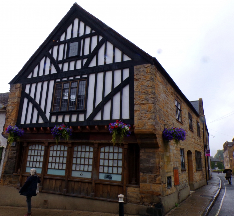
Corner block on south side of Abbey Road. Originally a late medieval timber-
framed building which was extensively restored in 1965. Facing Cheap Street
is a 3 storey gable end, oversailing at 1st floor level, the side walls
having stone corbels. 2 upper floors have modern timber- framing exposed.
4-light casements to lst floor, 1-light window above. Modern 4-light bank
windows inserted on ground floor. One moulded post with curved brace on
left hand side. Front facing Abbey Road is of stone rubble. 2 storey,
3 window front. Tile roof. Wood casements to 1st floor. Ground floor
has from left to right hand 1 2-light window, modern segmental headed doorway
with modern ledged and nail studded door, and a 4-light window. Internally,
an original doorway remains on the south side; a fireplace and a lst-floor
2-light window at the south end of the Cheap Street front were also both
discovered during the 1965 restoration. This building was at one time
the Tuck Shop used by Sherborne School and was known by the name of Noah's
Ark.
Nos 2 to 30 (even) and Nos 34 to 50 (even) form a group.
Listing NGR: ST6383416648
External links are from the relevant listing authority and, where applicable, Wikidata. Wikidata IDs may be related buildings as well as this specific building. If you want to add or update a link, you will need to do so by editing the Wikidata entry.


Other nearby listed buildings
