Approximate Location Map
Large Map »
Latitude: 50.7152 / 50°42'54"N
Longitude: -2.4367 / 2°26'12"W
OS Eastings: 369264
OS Northings: 90714
OS Grid: SY692907
Mapcode National: GBR PY.RG1M
Mapcode Global: FRA 57S6.2HN
Plus Code: 9C2VPH87+38
Entry Name: The Town Pump
Listing Date: 8 May 1950
Grade: II
Source: Historic England
Source ID: 1324413
English Heritage Legacy ID: 104236
ID on this website: 101324413
Location: Dorchester, Dorset, DT1
County: Dorset
Civil Parish: Dorchester
Built-Up Area: Dorchester
Traditional County: Dorset
Lieutenancy Area (Ceremonial County): Dorset
Church of England Parish: Dorchester and West Stafford
Church of England Diocese: Salisbury
Tagged with: Architectural structure
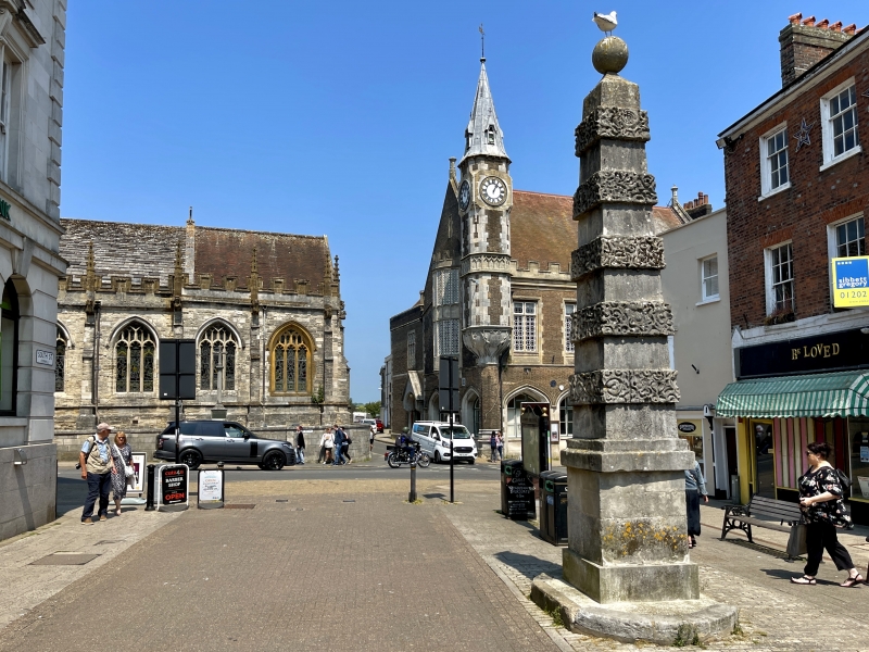
CORNHILL
1.
5191
The Town Pump
SY 6990 7/8 8.5.50.
II
2.
Stands in centre of street at north end. Square stone tapered shaft, crowned with
ball. Shaft has 5 vermiculated projecting stone bands. Square base, round lower base.
At one time town pump. Tablet commemorates its. erection in 1784 on the site of the
Cupola or Market House.
Listing NGR: SY6926390714
External links are from the relevant listing authority and, where applicable, Wikidata. Wikidata IDs may be related buildings as well as this specific building. If you want to add or update a link, you will need to do so by editing the Wikidata entry.


Other nearby listed buildings
