Approximate Location Map
Large Map »
Latitude: 50.7347 / 50°44'5"N
Longitude: -2.7537 / 2°45'13"W
OS Eastings: 346906
OS Northings: 93062
OS Grid: SY469930
Mapcode National: GBR PP.L08R
Mapcode Global: FRA 5734.K0R
Plus Code: 9C2VP6MW+VG
Entry Name: Port Bredy Hospital
Listing Date: 19 September 1975
Grade: II
Source: Historic England
Source ID: 1119024
English Heritage Legacy ID: 104474
ID on this website: 101119024
Location: Bridport, Dorset, DT6
County: Dorset
Civil Parish: Bridport
Built-Up Area: Bridport
Traditional County: Dorset
Lieutenancy Area (Ceremonial County): Dorset
Church of England Parish: Bridport St Mary
Church of England Diocese: Salisbury
Tagged with: Building
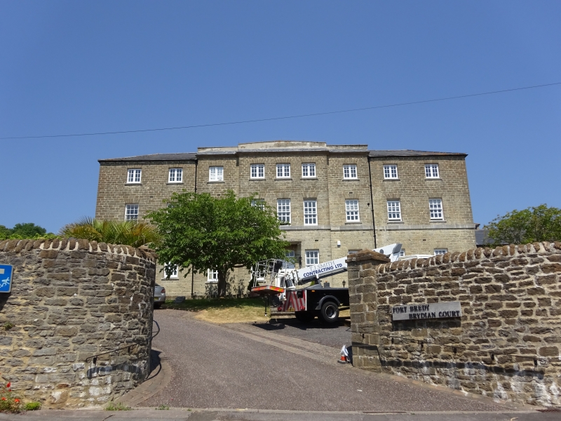
1.
5191 BEDFORD PLACE
(North Side)
Port Bredy Hospital
SY 4693 5/39
II
2.
1836 or shortly thereafter. Former workhouse. Hammer dressed stone. 3 storeys.
Characteristic cruciform workhouse plan. Front has 9 ranges of windows, sashes
on ground floor, casements above. Centre breaks forward twice and is crowned
by eaves cornice and blocking course. String at 1st floor level.
Listing NGR: SY4690693062
External links are from the relevant listing authority and, where applicable, Wikidata. Wikidata IDs may be related buildings as well as this specific building. If you want to add or update a link, you will need to do so by editing the Wikidata entry.


Other nearby listed buildings
