Approximate Location Map
Large Map »
Latitude: 50.6633 / 50°39'48"N
Longitude: -2.5985 / 2°35'54"W
OS Eastings: 357793
OS Northings: 85023
OS Grid: SY577850
Mapcode National: GBR PT.SS9V
Mapcode Global: FRA 57FB.5GY
Plus Code: 9C2VMC72+8H
Entry Name: Tithe Barn
Listing Date: 26 January 1956
Grade: I
Source: Historic England
Source ID: 1305209
English Heritage Legacy ID: 105139
ID on this website: 101305209
Location: Abbotsbury, Dorset, DT3
County: Dorset
Civil Parish: Abbotsbury
Built-Up Area: Abbotsbury
Traditional County: Dorset
Lieutenancy Area (Ceremonial County): Dorset
Church of England Parish: Abbotsbury St Nicholas
Church of England Diocese: Salisbury
Tagged with: Tithe barn Thatched building
SY 5785 ABBOTSBURY CHURCH STREET, EAST SIDE
10/20 Tithe Barn
26.1.56
GV I
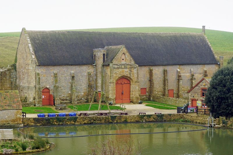
Tithe Barn, formerly of Abbotsbury abbey. c1400. Ashlar walls, weathered to
dressed stone. Thatch roof, originally stone-slab, covering the 12 bays of the
south-west end. Remaining 11 bays unroofed since C17. North wall from the sixth
to eleventh bay is destroyed. High plinth moulding carried round buttresses.
Buttresses form bay divisions, one high set-off and embattled pedestals above the
parapet. These survive at south west gable-end as right-angle and central table
buttresses, latter with a niched finial. Buttresses cut back with set-offs through
rest of building, when converted to a thatch roof. Alternate bays of south wall
with narrow loops, splayed internally. 6 loops graduated in size on south west
gable. Porches, originally two, one survives at bay 16 (N), with opposing projecting
entrances, bays 8 and 16. Moulded parapet across south west gable survives and
on south wall where plain stone spouts survive at bays 17, 20 and 21. Two-storey
porch (bay 16), with diagonal buttresses crenellated parpet, and stone-coped gable.
Tall 4-centred archway of 2 straight-chamfered orders. Stone newel-staircase in
angle with barn has 2 exits at parapet level, formerly to walkways. Interior of
porch formerly vaulted, corbels and springers of a quadripartite rib vault remain.
Projecting and opposing entrances on the south wall had formerly 4-centred and
chamfered openings, eastern blocked, western partly destroyed and altered. Both
have low gabled stone roofs and large segmental rere-arches. North wall of thatched
barn, with ashlar blocking, possibly C17. Interior, roof-construction of principals
with halved collars, projecting ashlaring carried on very short hammer-beams. No
purlins. C17. Arch-braced collar trusses survive in porch, eight very closely set
with ashlaring and clasped purlins, c.C14.
Scheduled Ancient Monument. (RCHM, Dorset I, p.6 (3).)
Listing NGR: SY5772385090
External links are from the relevant listing authority and, where applicable, Wikidata. Wikidata IDs may be related buildings as well as this specific building. If you want to add or update a link, you will need to do so by editing the Wikidata entry.


Other nearby listed buildings
