Approximate Location Map
Large Map »
Latitude: 50.6957 / 50°41'44"N
Longitude: -2.2749 / 2°16'29"W
OS Eastings: 380682
OS Northings: 88486
OS Grid: SY806884
Mapcode National: GBR 0ZY.7PF
Mapcode Global: FRA 6737.RJG
Plus Code: 9C2VMPWG+73
Entry Name: Obelisk in Moreton Park
Listing Date: 20 November 1959
Grade: II
Source: Historic England
Source ID: 1323330
English Heritage Legacy ID: 108647
ID on this website: 101323330
Location: Dorset, DT2
County: Dorset
Civil Parish: Moreton
Traditional County: Dorset
Lieutenancy Area (Ceremonial County): Dorset
Church of England Parish: Moreton St Nicholas
Church of England Diocese: Salisbury
Tagged with: Obelisk
SY 88 NW
4/187 MORETON
20.11.59
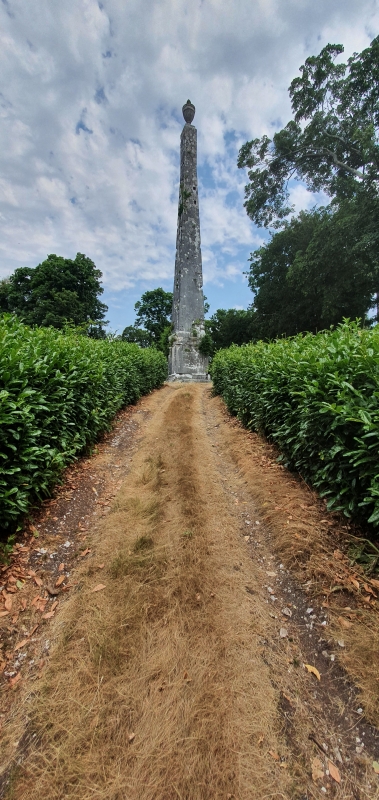
Obelisk in Moreton
Park
II
Obelisk. Built 1783-6 by Captain John Houlton, in memory of James Frampton. Ashlar
stone obelisk, 70 ft high, on a base with moulded plinth and cornice, surmounted by
an urn. Tablets with inscriptions now removed - see item
RCHM Monument 6.
Listing NGR: SY8068288486
External links are from the relevant listing authority and, where applicable, Wikidata. Wikidata IDs may be related buildings as well as this specific building. If you want to add or update a link, you will need to do so by editing the Wikidata entry.


Other nearby listed buildings
