Approximate Location Map
Large Map »
Latitude: 50.6777 / 50°40'39"N
Longitude: -2.2173 / 2°13'2"W
OS Eastings: 384742
OS Northings: 86473
OS Grid: SY847864
Mapcode National: GBR 21J.J6S
Mapcode Global: FRA 6778.XPW
Plus Code: 9C2VMQHM+33
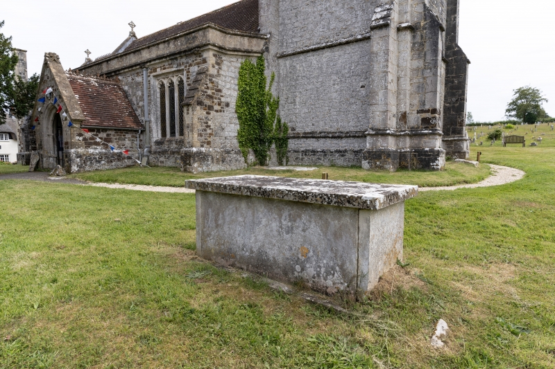
Entry Name: Table-Tomb in Churchyard 7 M North of the Tower
Listing Date: 2 October 1984
Grade: II
Source: Historic England
Source ID: 1152879
English Heritage Legacy ID: 108871
ID on this website: 101152879
Location: Holy Rood Church, Wool, Dorset, BH20
County: Dorset
Civil Parish: Wool
Built-Up Area: Wool
Traditional County: Dorset
Lieutenancy Area (Ceremonial County): Dorset
Church of England Parish: Wool, East Burton and Combe Keynes
Church of England Diocese: Salisbury
Tagged with: Architectural structure
SY 8486
19/410 WOOL CHURCH LANE
(South-West Side)
Table-tomb in
churchyard 7 m north
of the tower
II
Churchyard Monument. Plain stone table-tomb, probably C18 - inscription
obliterated.
Listing NGR: SY8474286473
External links are from the relevant listing authority and, where applicable, Wikidata. Wikidata IDs may be related buildings as well as this specific building. If you want to add or update a link, you will need to do so by editing the Wikidata entry.


Other nearby listed buildings
