Approximate Location Map
Large Map »
Latitude: 54.8423 / 54°50'32"N
Longitude: -1.579 / 1°34'44"W
OS Eastings: 427137
OS Northings: 549799
OS Grid: NZ271497
Mapcode National: GBR KDDF.YZ
Mapcode Global: WHC4B.QK96
Plus Code: 9C6WRCRC+WC
Entry Name: Railway Viaduct East of the Hermitage
Listing Date: 23 February 1987
Last Amended: 14 November 1997
Grade: II
Source: Historic England
Source ID: 1311261
English Heritage Legacy ID: 109372
ID on this website: 101311261
Location: Chester Moor, County Durham, DH3
County: County Durham
Electoral Ward/Division: Chester-le-Street East
Parish: Non Civil Parish
Traditional County: Durham
Lieutenancy Area (Ceremonial County): County Durham
Church of England Parish: Chester-le-Street
Church of England Diocese: Durham
Tagged with: Architectural structure Railway viaduct
CHESTER-LE-STREET A 167 (T)
NZ 24 NE 271497
(West side, off)
7/26 Railway Viaduct
east of The Hermitage
II
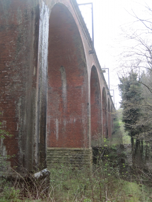
Railway viaduct carrying 2 tracks over Southburn Dene. 1868 for the North-
Eastern Railway Company. Light-red engineering brick in English bond; stone
plinths and parapet band.
Tall, c.200-metre long viaduct. 8 elliptical arches, in 7 rows of header bond,
on thin slightly-battered piers with tall rock-faced plinths; arches partly
refaced on west. Moulded band at track level. Low parapet with paired end
piers.
Late C20 railings and cantilevered refuges are not of special interest.
An important landscape feature.
Listing NGR: NZ2713749799
External links are from the relevant listing authority and, where applicable, Wikidata. Wikidata IDs may be related buildings as well as this specific building. If you want to add or update a link, you will need to do so by editing the Wikidata entry.


Other nearby listed buildings
